“The Mormon Pioneer Trail, 1846–47,” Ensign, Sept. 1979, 72–76
The Mormon Pioneer Trail, 1846–47
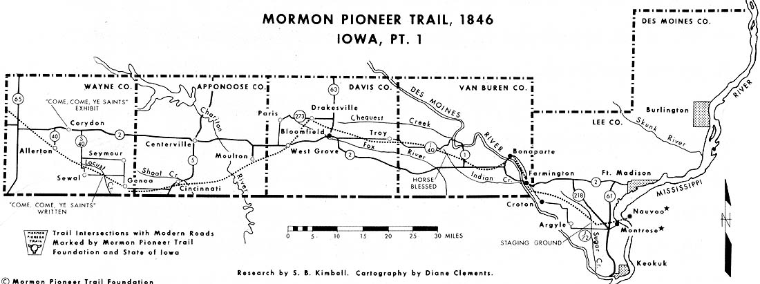
Across Iowa, 1846
The beginning of the great trek west really commenced 1 March 1846 on the frozen banks of Sugar Creek in Lee County, Iowa, seven miles west of the Mississippi River. On that day approximately three thousand men, women, and children in about five hundred wagons formally abandoned Nauvoo, Illinois, the City of Joseph, as a result of misunderstandings and mob activities. These were the vanguard, but thousands more were to follow that year, across the Mormon Mesopotamia between the Mississippi and Missouri rivers. As far as to Bloomfield, at least, the pioneers used established territorial roads. Thereafter they followed what primitive roads and Indian paths there were. Travelers today should watch for the more than one hundred road signs marking the trail across Iowa, erected in 1972 by the Iowa Highway Commission in cooperation with the Mormon Pioneer Trail Foundation.
Terrible weather and lack of preparation caused people and animals much suffering. The first known example of blessing a sick animal took place at Indian Creek in Van Buren County, an act occasionally done in pioneer days. The death of an animal was a serious loss.
Partially to buoy up the people, but more particularly in gratitude for the news that his wife Diantha Farr Clayton had safely born him a son in Nauvoo, William Clayton, camp clerk, wrote the words of the famous Mormon hymn, “Come, Come, Ye Saints,” on April 13 while encamped on Locust Creek. Commemorating this event is an impressive “Come, Come, Ye Saints” exhibit in the Wayne County Historical Society Museum in Corydon.
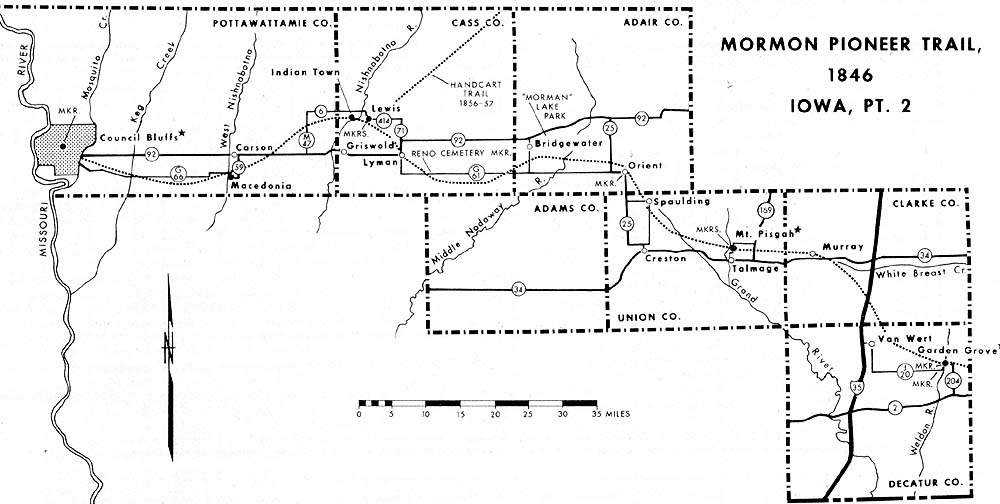
On April 23 the pioneers made camp on the west bank of the East (Weldon) Fork of the Grand River. Here the first permanent camp was built for the benefit of those following. The Saints remained here until May 12. They named the camp “Garden Grove” and a community of the same name still exists on this campsite. A brass marker in a large stone in the center of town honors these early settlers. One mile west of this marker, on the north side of the road, a small roadside park contains a monument honoring the Mormons who died in Garden Grove.
A week later they established another permanent camp at a place they called Mount Pisgah, located on another branch of the Grand River on Pottawattamie Indian lands. Fortunately the Indians were friendly.
Today the campsite is marked by a cemetery—a monument to the hundreds who died there between 1846 and 1852—and a nine-acre park and picnic area with information signs. There is also a Daughters of the American Revolution marker here commemorating Mount Pisgah as the first white settlement in Union Company, but omitting to mention that the settlers were Mormons. Mount Pisgah is located on a crooked country road north of Highway 34 or west of Highway 169. (Ask locally for directions.)
Leaving Mount Pisgah June 1, the pioneers continued west, passing through present-day Orient, where a marker on the school grounds notes that event. Near one of their campsites in Adair County, two miles east of Bridgewater, is modern “Morman” [sic] Lake, and a small Mormon Trail Park, commemorating their passing.
East of Lyman the old trail passes the site of an early post-Mormon town named Reno. In the Reno cemetery is a bronze plaque honoring those who used the Old Mormon Trail.
One mile south of Lewis is Cold Springs State Park, where a sawed-off telephone pole in the camping area marks the trail. Two other markers in the Lewis town park commemorate the trail.
Just west of Lewis, the Mormons passed a Pottawattamie Indian encampment on the Nishnabotna River which they dubbed Indian Town, a name which stuck for years. It was just at this point where, ten years later, the handcart companies from Iowa City would meet the 1846 trail and follow it to the Missouri River.
From Indian Town, the pioneers followed an Indian trail directly to Council Bluffs, the location of a Pottawattamie Indian agency. After examining several campsites on both sides of the broad Missouri, Brigham Young decided to set up Winter Quarters across the river at a place now known as Florence, Nebraska.
The first Mormon encampment was along Mosquito Creek near the present Iowa School for the Deaf on Highway 275. From this area the Mormon Battalion commenced their famous march to San Diego. Baylis Park, on South Main Street in downtown Council Bluffs, contains a boulder with two markers honoring the Mormon pioneers.
The Great Trek, 1847
The most famous of all Mormon treks began on 5 April 1847 when Heber C. Kimball moved a few wagons about three miles west of Winter Quarters, but it was not until April 19 that the whole group of pioneers, one hundred forty-three men, three women, and two children were organized and under way on their one-thousand-mile exodus. The appointed departure was on the Platte River near present-day Fremont.
In general the trail would follow the gentle, broad Platte River Valley for six hundred miles to Fort Laramie, Wyoming, where the pioneers picked up the Oregon Trail. They followed it to Fort Bridger, and then transferred to the faint trace left by the Reed-Donner party the preceding year. It took them into the valley of the Great Salt Lake.
Looking for an easy fording place, the pioneers crossed the Loup River near Fullerton and cut back to the Platte near today’s Grand Island. From there Interstate 80 follows the old trail closer than does the older Highway 30.
Near present-day Kearney, Nebraska, the Saints began to parallel the Oregon Trail, which, starting at Independence, Missouri, reached the Platte at this point. In the mid-1840s the south side of the river was the favored route, but earlier travelers had followed the north bank. The Latter-day Saints, nearly always keeping on the north side, actually were using an older branch of the Oregon Trail. Just west of Kearney the Saints first sighted and hunted buffalo.
Just inside Dawson County, Nebraska, the pioneers were threatened by prairie fire, but they sought refuge on Platte River islands. Although they were probably not aware of it, at today’s Cozad they passed the 100th meridian; to its west, rainfall would be so slight that most crops would need irrigation.
Along this stretch of the trail through Lincoln and Keith counties, William Clayton, tired of either estimating distances of counting the revolutions of a wagon wheel, suggested that some counting device be made. Orson Pratt designed and Appleton Harmon constructed the first odometer used by the Saints, first used near Paxton, Nebraska.
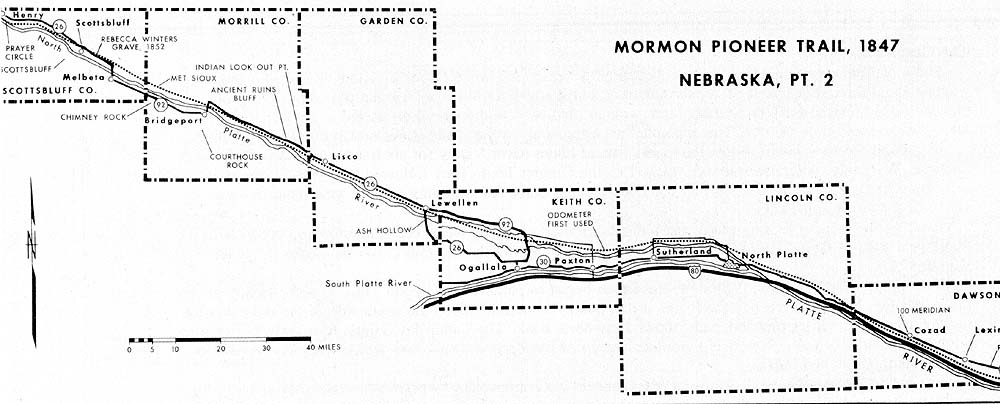
On May 20 they passed one of the most famous stopping places on the Oregon Trail, Ash Hollow. It was on the south side of the Platte, but the Mormons found it a good check on the accuracy of their maps. From here they entered broken uplands and the terrain became more dramatic. Soon they came to an Indian lookout point, a few miles west of Lisco, which several climbed. A few miles farther they camped by the Ancient Ruins Bluff, an impressive landmark on their side of the river in Nebraska. Most of the Quorum of the Twelve climbed it, wrote their names on a buffalo skull, and left it on the southwest corner of the bluff.
Soon afterward the pioneers spotted Courthouse Rock and Chimney Rock; Chimney Rock was the most famous landmark on the entire Oregon Trail. In the vicinity, they also met their first Great Plains Indians, a band of Sioux.
A little farther up the trail, today’s traveler can see Rebecca Winter’s grave; a member of one of the later companies, she died in 1852, and her grave is one of the few known of thousands of Mormon graves along the trail. To their left on the south side of the Platte ran the imposing Scotts Bluffs.
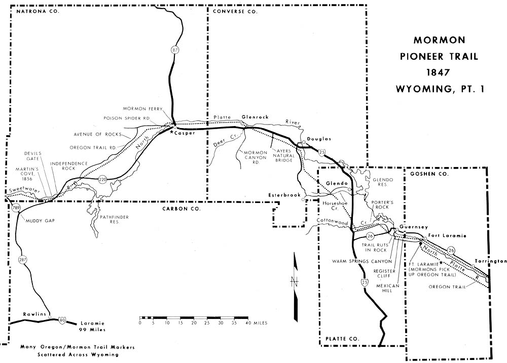
Just before leaving present-day Nebraska, near Henry on some small bluffs, the leaders put on their temple robes and held a prayer circle (William Clayton’s Journal, Salt Lake City, 1921, pp. 202–03), something they did on occasion. In early June they reached Fort Laramie in Wyoming, crossed the Platte southward, and picked up the Oregon Trail. Near Guernsey are located Register Cliff, Mexican Hill, Warm Springs Canyon, and the most famous of all the Oregon Mormon Trails ruts, cut at least five feet deep into solid rock. (Ask locally for directions.)
Between Guernsey and Douglas, the trail is difficult to follow. The very curious will want to visit Porter’s Rock, probably named for Porter Rockwell, located near the center of Platte County, north of Cottonwood Creek, but detailed maps and rough-terrain vehicles are necessary. West of Douglas is Ayers Natural Bridge, unusual because the stream which created it is still running through it. Old pioneer journals mention visiting this natural wonder. Out of Glenrock one can drive up Mormon Canyon where some Mormon families lived in the mid-1850s, and walk or drive up Deer Creek Canyon about a quarter of a mile to see the rocky bluffs which Brigham Young and Heber C. Kimball scrambled up when they saw a mother grizzly bear ambling toward them. (Ask locally for directions.)
At present-day Casper, Wyoming, Mormons and Oregonians alike crossed the Platte to the north bank at the place known as Last Crossing. Here the pioneers built and maintained a ferry for themselves and the thousands who would follow. The now-restored post-Mormon Fort Caspar is at the location of the old Mormon ferry.
One of the most scenic and original sections of the old trail which can be followed by a standard automobile today are Poison Spider and Oregon Trail roads leading toward Independence Rock. Although most of the road is dirt, it is a good road. (Ask locally for directions.)
Many pioneers and later Mormons climbed Independence Rock and scratched their names on it. In the same area is Devil’s Gate, through which flows the Sweetwater River, a gentle and beneficent stream which the pioneers followed, with frequent crossings, for ninety-six miles. Also in the same general area is Martin’s Cove, where during November 1856 many of the fifty-six members of that handcart company who died en route froze to death in Wyoming snows. Travelers can see these sites from a new roadside turnout on Highway 220. It is possible to visit Devil’s Gate and Martin’s Cove, but permission and directions from ranch owners are required and four-wheel drive vehicles are recommended.
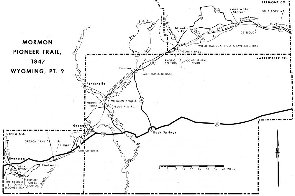
Passing and noting Split Rock in Fremont County, the pioneers soon reached another favored spot on the trail, the ice slough. Then (and sometimes even today) refreshing ice could be found a foot or so beneath the boggy ground. Just west of here, the adventurous can follow a very difficult jeep trail along the Sweetwater to Rock Creek, location of the Willie Handcart gravesite. This company was trapped by the same winter snows which devastated the Martin Company. An easier way to this grave is via Atlantic City. (Ask locally for directions.)
Today it is possible to follow the pioneer trail to South Pass only on foot or dirt bike. One may, however, reach South Pass and another famous stopping place, Pacific Springs, via dirt roads off Highway 28. A Fremont County map is recommended. Travelers also may get an excellent view of these places from a roadside turn-off just beyond the divide, south of Highway 28.
Somewhere along the Dry Sandy, a renowned meeting with Jim Bridger took place and the pioneers accepted his legendary challenge to grow crops in the Great Basin. In Farson the traveler must make a decision—to drive to Granger via Rock Springs or, preferably, along the good dirt Farson Cutoff Road via Fontenelle. Either route detours from the trail, for the older bridge across the Green River no longer exists.
From Granger it is possible and exiting to take the much deteriorated old Highway 30 following the pioneers through a lunar landscape of the badlands to Church Butte, so named because some Mormons supposedly held church services here. (Ask locally for directions.) Another way to reach this point is via a dirt road going north at the Church Butte exit off Interstate 80.
On July 7, the pioneers reached Fort Bridger, where the Oregon Trail turned north. After a short rest, they picked up the barely visible trace of the Reed-Donner party into the valley of the Great Salt Lake. Part of this trail can be approximated by taking the Leroy exit off Interstate 80 to abandoned Piedmont, then following a dirt road to “Bear Town” on the Bear River. Here the Mormons went down Coyote Creek Canyon to what is now the Utah border. (Ask locally for permission and directions; otherwise you must get to Echo Canyon via Evanston.) One mile east of The Needles, a prominent rock formation at the mouth of Coyote Creek Canyon, Brigham Young was stricken with mountain fever. As a result, the pioneers split into three divisions—a vanguard, the main company, and a rear guard with Brigham Young. This rear guard entered present-day Utah July 15.
The Utah portion of this map, as well as maps of other trails, will be published in subsequent issues.
Mormon Pioneer Trail, 1846
Iowa, Pt. 1
Mormon Pioneer Trail, 1846
Iowa, Pt. 2

Mormon Pioneer Trail, 1847
Nebraska, Pt. 1
Mormon Pioneer Trail, 1847
Nebraska, Pt. 2
Mormon Pioneer Trail, 1847
Wyoming, Pt. 1
Mormon Pioneer Trail, 1847
Wyoming, Pt. 2