“In Search of Lehi’s Trail—Part 1: The Preparation,” Ensign, Sept. 1976, 33
In Search of Lehi’s Trail—
Part 1: The Preparation
For 146 years, readers of the Book of Mormon have in their mind’s eye traveled and camped with Lehi as he solemnly led his family from Jerusalem, trudged southward to the Red Sea, and moved periodically down the Red Sea coast until the group turned inland and crossed through “much affliction” before coming to a coastal area they said was bountiful.
Readers have contemplated that historic journey—where Lehi’s party stopped, where they built their ship, and where they landed in the western hemisphere, the land promised to Lehi.
For us, thousands of years and miles from its culture and locales, the Bible comes more easily to life when we see photographs of the mountains, valleys, and towns of Palestine, and the areas of the Roman world into which the gospel of the New Testament was carried. Modern Church history and the revelation of Joseph Smith mean more to us when we see the New York, Ohio, Missouri, and Illinois environs of the early Latter-day Saints.
Because of this, when the Church announced its eight-year adult gospel curriculum, we contemplated how we could best support this inspired call to “get into the scriptures.” The idea to investigate the general area of Lehi’s journey soon presented itself, and in 1972 we started to discuss the likelihood of such a venture.
We planned to photograph the area outlined by Dr. Hugh Nibley in his series, “Lehi in the Desert,” which was published in the Improvement Era in 1950. After learning more about Dr. Nibley’s reasons for identifying the general locales, we began to plan how to travel the Arabian Peninsula. A look at the map told us that Lehi’s trail went through lands that were difficult to enter today, lands misunderstood by many in the Western world, and we could see that the venture would entail a number of hazards and concerns.
After considerable inquiry, it was clear that not just anyone could make this trek. It required someone who not only loved the Book of Mormon but also knew and understood the Arab world, could speak Arabic, had experience in traveling there, and could devote several months to the venture.
The names of Lynn M. Hilton and his wife, Hope, came to mind. Their credentials for the adventure were clear. Brother Hilton, with a Ph.D. from the University of Chicago in educational administration, had spent eleven years in adult education at Brigham Young University, including travel study tours. His subsequent twelve years were spent as a co-owner of a travel-study firm that took him dozens of times to Europe, the Middle East, Africa, and Asia. In the 1960s, the Hiltons, because of their love of the Middle East, including the Arab nations, established a foundation to give annual scholarships and educational support to students of the Arab world. Since then they have established businesses in Cairo, Egypt. We approached them with the idea of investigating the possible locales of Lehi’s journey in Arabia.
Brother Gerald Silver, a photographer for the Church’s daily newspaper, Deseret News, was asked to accompany the Hiltons and record the scenes of the adventure.
The Hiltons and Brother Silver took an idea and turned it into a memorable Latter-day Saint adventure story. Their conclusions are tentative, of course; the Church does not have an official view on the matter. As the Hiltons are wont to say, “Until someone finds a sign saying, ‘I, Lehi, was here,’ our report will always be in the realm of a respectable possibility. But we think that we found far more than we Latter-day Saints ever knew existed concerning Lehi’s route. We think our adventure not only illuminates some of the vital elements of the Book of Mormon story, but also throws new light on the contributions of Arab culture to the Book of Mormon story.”
We invite you to enjoy this fascinating two-part Mormon odyssey: “In Search of Lehi’s Trail.”—Jay M. Todd, managing editor.
Part 1: The Preparation
Our journey in search of places where Lehi might have traveled was a time of miracles, small and great. We had begun it with heart-fluttering trepidation. We completed it with heartfelt rejoicing, having truly felt the Lord’s hand in our lives. For instance:
—Previous visits to the Middle East had inevitably brought at least a few days of illness; on this journey, we experienced four weeks of vigorous health.
—In a freezing snowstorm in Amman, Jordan, we had just turned away from the tenth overcrowded hotel that had not been able to accommodate us when a complete stranger appeared and offered us the hotel room of a friend who had left the city for three days. He refused payment for this kindness.
—As a matter of standard policy, two of the countries we needed to visit simply do not admit tourists for any reason, yet we received visas to these lands that Lehi, we feel, also visited. A resident of one of these countries told us he had never heard of people receiving entry visas as we had.
—At one point we were in a war zone, so close to the fighting that we could hear rifle fire crackling in the surrounding hills; yet we saw what we needed to see and left without harm.
—Taking films and pictures in many areas on our route was discouraged, both for military and for cultural reasons though not prohibited; yet Jerry Silver, our photographer, brought home over 6,100 colored slides, having had only three rolls of film withheld by local authorities.
—In the teeming city of Jiddah, which bulges with international businessmen drawn there by economic opportunities in the oil-rich kingdom of Saudi Arabia, another miracle happened that we will never forget. As Lynn later related: “My wife and daughter arrived in Jiddah two days before me. We were to meet at a prearranged hotel room, or if that failed, through a mutual friend. But Hope and Cynthia had trouble finding a hotel room since women almost never travel unescorted in the Middle East, and when I tried to locate them, I found that our friend’s phone number had been written down wrong. I felt near desperation; there are almost a million people in Jiddah. I decided to go back to the hotel and ask the clerk to search again for a message. It was past midnight when I turned on a street that I’d never noticed before. The thought crossed my mind that it might be a shortcut to the hotel. Suddenly, in the middle of the block, something whispered to my soul, “Check there for Hope and Cynthia.” I was in front of the Al-Rihab Hotel, one of a hundred hotels in the city. Minutes later, we were reunited in tears of grateful rejoicing.”
—Prior to our trek, we had wondered if our friends in the Middle East would accept our assignment and help us accomplish our goal. They did. They did more. They accepted the goal itself. Mrs. Rihab Ouri of Beirut, a good Muslim friend, summed up the kind of cooperation we received in a letter written after our return: “Did you find the early Mormons of Saudi Arabia?”
These were only a few of the miracles the Lord performed through both friends and total strangers along the way, helpers whose knowledge and influence enabled us to open the right doors and interpret what we saw inside. And we know that our quest would have been impossible—even foolish and ridiculous—without such helps.
Just consider the scope of the challenge! We were to follow a trail that had been cooling for more than 2,500 years—a trail that lay half a world away in war-torn territory now divided between Oman, Saudi Arabia, Jordan, and Israel. All of the clues to Lehi’s route are contained in a mere eighteen chapters that Nephi wrote years after his journey; and the main purpose of the record was not to record geography and caravan routes but those marvelous visions given to his father and later to himself.
Then consider our own qualifications. We loved the Middle East, had many friends there, and had visited its cities often. We had studied its languages, history, and culture but did not have advanced degrees in Middle Eastern studies. We loved the Book of Mormon and had sincere testimonies of its truthfulness, but we were not sophisticated scholars in that field either. But we had an assignment, we knew that the Book of Mormon is true, and thus started from the premise that what Nephi wrote actually happened. Inspired by God, Mormon had included Nephi’s own record without abridging it. Inspired by God, Joseph Smith had translated it, literally and faithfully. The hypothesis and conclusions that we will present, of course, are tentative; it will take archaeologists and historians to provide further supporting evidence. But the story of our search for Lehi’s route is an exciting adventure—an adventure that has resulted in some basic conclusions as they relate to actual geographic locales mentioned in the Book of Mormon.
One of the encouraging factors in our search was the discovery of the great timelessness of the Arabian peninsula. It is a changeless place, not only geographically but culturally. It’s hard for people in highly developed areas of the world to imagine a place staying the same for two thousand years. We look at the world from our twentieth-century perspective where technology’s immense power transforms landscapes into cities within weeks. But technology’s impact has not reached much of Arabia.
The history of Arabia is written with water, not ink. Where there is water, there is life—that is the inescapable fact of Arabian life—and the great oases of the Arabian peninsula do not move from place to place. Cities cannot thrive in the desert, and there is a limit on how far suburbs can extend from the great central wells and springs.
There are three major events of the last 2,500 years of Arabian history. Arabs refer to these events with knowledgeable familiarity, as though they took place yesterday:
1. The breaking of the Marib Dam. Shortly before Lehi, some heroic but nameless leader undertook the gigantic engineering feat of constructing this dam or dike. Some experts think that the builders were the Sabean Kings and that their kingdom was ancient Sheba where the Queen of Sheba who visited Solomon came from (1 Kgs. 10. See Gus W. Van Beek, “The Rise and Fall of Arabia Felix,” Scientific America, Dec. 1969, 221:41.) They date the building of the dam from 750 B.C. (Fr. Eugene Hoade, East of the Jordan, Jerusalem: Franciscan Printing Press, 1966, p. 318.) Rainwater diverted by this dam or dike increased the agricultural fertility of up to 4,000 acres of the land until it supported a significant population. (Van Beek, p. 43.)
According to the foremost scholar of the subject, the Marib Dam broke in the sixth century A.D. (Van Beek, p. 39.) Many survivors of the resultant flood, faced with starvation, fought their way north, carving out with the sword a place for themselves among the central and northern Arabian clans or families and creating social chaos and hostility. The wars that followed lasted centuries. Families in Arabia today still remember that they came from Marib and refer to the breaking of the dam as though it had happened in their grandfather’s time. Its ruins still lie in the southwest corner of Arabia in Yemen, probably the most fertile spot on the peninsula.
2. The life of the Prophet Mohammed. Mohammed’s religious mission in the seventh century A.D. resulted in millions of conversions from India to Spain. For the first time, religion united Arabs and their neighbors across the barriers of waterless sand. Mohammed brought the age of enlightenment to the Arab world—an enlightenment which had a direct impact on the Renaissance in Europe. (See Philip K. Hitti, The Arabs: A Short History, Chicago, Henry Regnery Company, 1966, p. 187.)
3. The discovery of oil. Thirteen centuries after Mohammed, in the 1940s, the discovery of oil brought the legendary riches of King Midas to countries where donkeys and camels, mud-brick houses and goat-hair tents had been the measurement of wealth. Now wells can be drilled, pipelines constructed, vast areas and many people freed from the oases’ limitations.
But between these three events, Arab memory floats over legendary and contemporary battles, the reign of kings, good harvests and bad droughts. All events—past, present, and future—are inshalla (God wills it), and a thousand years is little different from a hundred. The Lord knew the when, how, and where of Lehi’s journey. As readers of the Book of Mormon, we also knew the when. And we were determined to piece together whatever clues we could find that might aid our understanding of the how and the where.
We started with the Book of Mormon. Read along with us as we discover what it tells us about that journey, and consider some of the kinds of questions that came to our minds as we poured over and over these passages from First Nephi. First, in chapter one, we read that Lehi had “dwelt at Jerusalem in all his days.” (1 Ne. 1:4.) (Did at Jerusalem mean something different from in Jerusalem?) A few verses later, Lehi “went forth,” then “returned to his own house at Jerusalem.” (1 Ne. 1:5, 7.) (Does this mean that he went out of Jerusalem, then came back to Jerusalem? What business would take him forth from Jerusalem?) In chapter 2, the Lord commands Lehi to “depart into the wilderness.” (1 Ne. 2:2.) (What would wilderness mean to Lehi?) Later they leave “the land of his inheritance, and his gold, and his silver, and his precious things.” (1 Ne. 2:4.) (Now, why wouldn’t he want to take gold and silver? Wouldn’t they need at least some money? Or does this mean their many objects of gold and silver?) Lehi “took nothing with him save it were his family, and provisions and tents.” (1 Ne. 2:4.) (What kind of provisions might they carry? How would they travel with tents? Would this life-style be anything like the nomadic life of the Bedouins in contemporary Arabia?)
Some clues about direction are in verse five: “And he came down by the borders near the shore of the Red Sea; and he traveled in the wilderness in the borders which are nearer the Red Sea.” (This is really intriguing. What’s the difference between “borders near” and “borders nearer”? At least the Red Sea is a definite landmark. Is there a trail that goes “near” and “nearer”?) In the next verse, the account specifies that “when he had traveled three days in the wilderness, he pitched his tent in a valley by the side of a river of water.” (1 Ne. 2:6.) (Note: three days of traveling in the wilderness after they had reached the Red Sea, not three days from Jerusalem. Would it be possible to identify that river and that valley?)
In another verse is an even more specific clue: “It [the river] emptied into the Red Sea; and the valley was in the borders near the mouth thereof.” (1 Ne. 2:8.) (Is it possible that Lehi’s tents could have been inland from the Red Sea?) This is the valley he called Lemuel and the river he called Laman, and in describing it we get a few more clues: “The river emptied into the fountain of the Red Sea” (Does fountain suggest anything special?), and Lehi told Laman that he should be “like unto this river, continually running into the fountain of all righteousness!” (1 Ne. 2:9.) (Are there any continually running rivers in Arabia?) He wanted Lemuel to be “like unto this valley, firm and steadfast, and immovable in keeping the commandments of the Lord!” (1 Ne. 2:10.)
Then Nephi explains, “And my father dwelt in a tent.” (1 Ne. 2:15.) (Did he mean this to imply some kind of long-term arrangement?)
When the journeys back and forth to Jerusalem began, the record made some interesting turns of language. For example, when Nephi and his brothers went for the brass plates, they took their tents and went “up to the land of Jerusalem.” (1 Ne. 3:9.) (Why did they take their tents with them? And was Jerusalem “up” from all points of the compass?) They ran into problems with Laban and decided to go “down to the land of our inheritance” and collect some of the gold and silver that they had left. (1 Ne. 3: 22.) Then they “went up again” to Laban’s house in Jerusalem. (1 Ne. 3:23; see also 1 Ne. 4:4, 34, 35; 1 Ne. 5: 1.)(This is very intriguing. To where would they go “down” to get to the land of their inheritance after they had gone “up” to Jerusalem? Was “down” in the same direction for both the wilderness and the land of their inheritance? And how far were they from Lehi’s camp by the Red Sea?)
When Nephi returned with the brass plates, Lehi “did offer sacrifice and burnt offerings unto the Lord.” (1 Ne. 5:9.) (Where did the sacrificial animals come from? Did they have them with them—or were there people nearby from whom they could have purchased animals?) In chapter 7, Nephi and his brothers return for Ishmael’s family and we see the same terminology of going “up” to Jerusalem and “down” to the wilderness. (1 Ne. 7:2–5.) (How long a wait was there between the time they got the brass plates and the time they made this second trip back?)
In chapter 16, they received the Liahona and “did gather together whatsoever things we should carry into the wilderness, and all the remainder of our provisions which the Lord had given unto us” [1 Ne. 16] (Were there other provisions than the ones they had brought with them out of Jerusalem?) “and we did take seed of every kind.” (1 Ne. 16:11.) (Where did they get seed? Did they harvest it? Buy it? Had they brought it with them?)
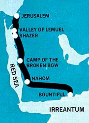
In the next verse, “We did take our tents and depart into the wilderness, across the river Laman.” (1 Ne. 16:12.) (Does this mean that Lehi’s camp had been on the west side of the river? Were they now proceeding south on the east side?) Then in 16:13 they made a sprint, it seems, for four days in “nearly a south-southeast direction,” finally pitching their tents in a camp they called Shazer. [1 Ne. 16:13] (Where did they end up after that four-day march?)
“And we did go forth again [so they must have stayed there, for a while at least] in the wilderness, following the same direction [this must be south-southeast], keeping in the most fertile parts of the wilderness, which were in the borders near the Red Sea.” (1 Ne. 16:14.) (What would be the most fertile parts?)
And how long did they go this time? Nephi’s only answer is “for the space of many days [does that mean a more leisurely but continuous journey?], slaying food by the way, with our bows and our arrows and our stones and our slings” (1 Ne. 16:15) until they needed to rest (1 Ne. 16:17).
Then disaster struck. In verse 18, Nephi’s bow “made of fine steel” breaks and his brothers are upset because “their bows [had] lost their springs.” (1 Ne. 16:18.) (What would cause a steel bow to break and other bows to lose their springs?)
After Nephi made a new bow and arrow out of wood and hunted for food (1 Ne. 16:23, 31) (What kind of wood could he find in the desert? What kind of animals could he hunt?), they “did again take our journey, traveling nearly the same course [that’s important in determining their direction] … for the space of many days.” Then, Nephi specifies, “we did pitch our tents again [It has a semipermanent sound, doesn’t it?] that we might tarry for the space of a time.” (1 Ne. 16:33.) (Now, where would this have been? And what is “the” space of “a” time? It almost sounds as though there were a defined amount of time involved.) Then Ishmael “died, and was buried in the place which was called Nahom.” (1 Ne. 16:34.) (Called Nahom by whom? Why would they have buried him there? How long would the predeath illness, burial, and mourning ceremonies be likely to take?)
In chapter 17, they begin traveling again, but this time they head “nearly eastward from that time forth.” (Was that until they reached the end of their journey?) “And we did travel and wade through much affliction in the wilderness.” (1 Ne. 17:1.) (Is there a difference between traveling and wading? What does “much affliction” mean?)
In verse 2, we discover them living “upon raw meat.” [1 Ne. 17:2] (Was this the “much affliction”? Why would they have needed to eat meat without cooking it?)
After sojourning eight years in the wilderness (1 Ne. 17:4), “we did come to the land which we called Bountiful, because of its much fruit and also wild honey.” (Honey implies there were flowers and flowering crops like alfalfa.) “And we beheld the sea, which we called Irreantum [must be different from the Red Sea], which, being interpreted, is many waters.” (1 Ne. 17:5.) (Was it bigger than the Red Sea?) They then pitched their tents “by the seashore.” (1 Ne. 17:6.) (So there must have been a hospitable beach or at least a meadow-like stretch where they could put their tents and animals.) In verse 7, Nephi “went up into the mountain” [1 Ne. 17:7] (Is there only one? It must have been nearby) and inquired of the Lord where to “find ore to molten.” (1 Ne. 17:9.) (Were there ore deposits nearby?) He then made “tools of the ore which I did molten out of the rock.” (1 Ne. 17:16.) (About how long is that process? What kind of tools would he have needed?)
Nephi’s brothers rebelled because of their hardships and when Nephi chastised them, they became angry and “came forth to lay their hands upon [him], … to throw [him] into the depths of the sea.” (1 Ne. 17:48.) (You can’t do that from a sandy beach; it would seem that there must be cliffs at Bountiful.)
Thwarted by the power of God, which made them tremble, they began to cooperate with Nephi in building the ship, which he stresses three times in 18:2 was “not after the manner of men.” [1 Ne. 18:2] (How did he know what shipbuilding “after the manner of men” was like? How was his different? What was it made of? Were there trees big enough at Bountiful to form ship timbers?) Finally, “after we had prepared all things, much fruits and meat from the wilderness, and honey in abundance, and provisions, … we did go down into the ship, with all our loading and our seeds.” (1 Ne. 18:6.) (Seeds again—had they harvested another crop? What provisions would they have been likely to take? How long a voyage was contemplated? Was the land Bountiful relatively small so that it was not an elaborate journey to go hunting in the wilderness?)
Those are some of the clues that Nephi gives us and those were some of the questions that came to our minds. So we started thinking, piecing together possible answers to our questions and examining scholars’ works, both ancient and modern, for whatever help they could give us.
As we prepared to make our journey, we wrote letters to over one hundred Arab friends in seven Middle East countries, explaining our plans. We were astonished and overwhelmed with gratitude at their enthusiastic responses and offers to help. All seemed anxious that we succeed in our search, for we would be looking in the ancestral homeland of all Arabs, the Saudi Arabian peninsula. These friends, we felt, would be the key to unlocking our understanding of Nephi’s words. Our supposition proved true.
As important as the information we collected from our research were the interpretations of that research and the insights and information shared willingly by a host of friends. We especially would not have been able to succeed without the second-mile efforts and cooperation of Salim Saad of Amman, Jordan; Angie Chukri of Cairo, Egypt; Hassib Dajani of Jiddah, Saudi Arabia; Sheik Helwan Habtar of Abha, Saudi Arabia; Sa’adi Fatafitah of Tarqumia, Westbank via Israel; and Nabeel Mustakim of Jerusalem, Westbank, via Israel.
Thus armed with the advice of many, we immediately began local library research. Ladd and Barbara Petty of Salt Lake supplemented this phase by their research for us in the Los Angeles Public Library. Interviews with Middle East scholars of both the University of Utah and Brigham Young University prepared our minds for the task ahead. Insight came from professors Sami Hanna, Aziz Atiya, Sidney B. Sperry, Ross T. Christensen, Hugh Nibley, and LaMar C. Berrett.
Gradually a clear picture began to emerge. We realized a cursory reading of the Book of Mormon might give the impression that Lehi and his family traveled into a desert vacuum, barren of people and civilization; yet a more careful reading of the text contains several clues indicating inhabited regions. Lehi could not travel without food and water for his family and his beasts of burden. Nephi records no miraculous manna descending to feed them—they had to work hard for their food and sometimes complained because of hunger. No waters are reported gushing miraculously from their own rocks of Horeb as Moses had produced with the touch of his rod. The family, therefore, must have traveled and survived as other travelers of their day did in the same area, going from public waterhole to public waterhole. (Of course, they also had the heaven-sent Liahona to help them.) As we traveled through the Middle East, we never saw a freshwater source devoid of people; where water is so precious, it is unlikely that many waterholes are unknown.
One campsite, Nahom, must have been a settled place, because Nephi says it “was called Nahom” and every other named campsite—the valley of Lemuel, the camp at Shazer, the land Bountiful—they named themselves. Of course, these places may also have been common oases that were simply renamed by Lehi. It is the habit of Semitic people to name things after their personal experience; and because these places had such great meaning to the Lehi group, Lehi apparently gave them private names known to all persons in the family to help implant his teachings.
Nephi periodically tells us that the group offered animal sacrifices. Where did these animals come from? Goat and sheep flocks, which wander all over the landscape in search of forage, would have slowed their journey to a snail’s pace, and, unlike the camel, goats and sheep require water every day. However, Lehi could have purchased or traded for these animals from local Bedouin herders and still have traveled at normal caravan speed.
Concerning the presence of other people, there can be no doubt that nomadic Bedouin tribes occupied the Arabian peninsula from ancient times. For example, Jethro, “the priest of Midian” and father-in-law of Moses, lived as a Bedouin in the land of Midian. (Ex. 2:16; Ex. 3:1.) This area in northwest Saudi Arabia, through which Lehi probably journeyed, had a vast livestock population: the armies of Israel after conquering Midian took as booty 675,000 sheep plus much other treasure. (Num. 31:43.)
Another evidence of inhabited regions along Lehi’s route is found when Nephi began to build his ship: he specified that he did not “build the ship after the manner of men.” (1 Ne. 18:2.) Could he have written such a statement if he had not seen ships? It was extremely eye-opening to us to discover that all along the coast of the Red Sea are shipbuilding villages where the ancient art has been practiced for generations upon generations.
That there were villages and a well-established civilization in the barren wilderness along the Red Sea shore within 600 years of Lehi’s day is verified for us by two eye-witness accounts. (See Illustration 1.)
Illustration 1
Two Ancient Reports Possibly Related to the Lehi Trail
600 B.C.
Probable Lehi trail

24 B.C.
Strabo
Reports on an ill-fated 10,000-man Roman expedition that marched over much of the probable Lehi Trail.

A.D. 57
Periplus
From a Greek who sailed from Egypt to India.
Using first-hand accounts, Strabo, a Greek historian, wrote of the ill-fated Roman army of 10,000 infantrymen that left Egypt in 24 B.C. under Aelius Gallus to capture the “incense country” in southern Arabia. The soldiers traveled much of what we shall present as the probable Lehi trail and confirmed that many people lived along the route; that the route itself was important and well known, extending north from where they landed in Arabia at Leucê Comê to Petra in Jordan; that the journey was difficult (the majority of them died of starvation, thirst, and illness, primarily because of their disloyal guide); and that they had to carry water on camels and buy their provisions from the Arab “hucksters and merchants.” (Strabo of Amasia, The Geography of Strabo, trans. Horace Leonard Jones, London: William Heinemann LTD, 1930, 7:353–63.)
An unknown Greek author wrote a travelogue called The Periplus of the Erythraean Sea around A.D. 57. He sailed around the Arabian peninsula touching at many ports that fall along Lehi’s probable route. This volume gives an eyewitness verification that within 600 years of Lehi’s time there were many villages and markets, a heavy traffic in frankincense from Oman, extensive shipping, and regular monsoon winds along the route. (The Periplus of the Erythraean Sea, trans. Wilfred H. Schoff, New Delhi, India; Oriental Books Reprint Corp., 1974.)
An even earlier account comes from the Greek historian Herodotus, who lived from 485 to 430 B.C. and wrote within 150 years of Lehi’s time. He said that “Arabia is the farthest of inhabited countries towards the south; and this is the only region in which grow frankincense [and] myrrh.” (Herodotus, trans. Rev. Henry Cary, London: George Bell & Sons, 1891, p. 215.) Herodotus also reported on the distance of eastern Arabia from Memphis: “I have heard that it is a two months’ journey from east to west; and that eastward its confines produce frankincense.” (Herodotus, p. 97.) He said that Arabians rode camels, which are “not inferior to horses in swiftness, and are much better able to carry burdens.” (Herodotus, p. 214.)
Thus, it was a major discovery for us to find that both modern and ancient maps of the area show that among the most heavily traveled roads of the ancient world are the generally well-known frankincense trails. One ran along the Red Sea Coast about three-quarters of the length of the Arabian peninsula, then turned eastward. At Najran it again turned south into the Yemen. The second route roughly paralleled the first a hundred or more miles inland, intersecting the coastal route at Najran. This route, however, ran eastward from Najran to Salalah. These routes were in common use at least 900 years before Lehi’s day and likely even 2,200 years before. (See The Periplus, pp. 120–21.) Evidence of both these roads is ample even today. (See Illustration 2.) Both routes are easy to follow from the crumbling ruins of strategically placed stone forts built in the tenth century B.C. by the Sabaean civilization, then added to by the Nabateans and later by the Romans as they sought to protect the passing caravans. These forts were also used as taxing points for the kingdoms through which the trails passed.
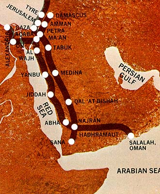
Illustration 2
Ancient Frankincense Trails from Salalah to Egypt and the Mediterranean
Also, from Petra in Jordan to Najran in southern Saudi Arabia near the nineteenth parallel of north latitude, the trail route is easily identified by the desert graffiti carved by thousands of camel drivers in the flat stones of the hills on both sides of the route. These traders plied their monotonous way northward leading heavily laden camels whose precious cargo of frankincense fed the insatiable appetites of the temples in Jerusalem, Egypt, and Babylon.
We should note that the term trail is apt to be misleading. It does not refer to well-defined, relatively narrow paths or roadways, but to more general routes that followed through this valley, that canyon, etc. The width of the route varied with the geography, ranging from a half mile to a dozen miles wide. Travelers could thus camp great distances from one another and still be at the same point on the same trail.
As for the major purpose of the trail, the frankincense trade was heavy as well as lucrative. Some idea of the extent of this traffic is had from the fact that anciently five sizable Arab kingdoms—Saba (Sheba), Qataban, Hadhramaut, Ma’in, and Ausan (Van Beek, p. 41)—in the southwest corner of Arabia were supported in high style by it. Three hundred years before Lehi, King Solomon received “spices” from the queen of Sheba. (2 Chr. 9:1.) Both Isaiah and Jeremiah speak of incense coming from Sheba (see Isa. 60:6 and Jer. 6:20), and Isaiah assures us that the Arabs of Midian, the area east of the Gulf of Aqaba, were caravaneers and possessed a “multitude of camels” (Isa. 60:6). The Old Testament also reports that in the days of the judges these same Midianites had “camels … without number, as the sand by the sea side for multitude.” (Judg. 7:12.) The travel up and down the 2,100-mile frankincense trail was heaviest in Lehi’s very era. (Van Beek, pp. 36–44.)
Thus, we found that there existed a well-traveled, south-southeastern route along the Red Sea coast. We think that Lehi would not have left an established path to roam on waterless mountains and deserts. The Book of Mormon does not say he was hiding on this leg of his journey, nor does it say he was fleeing as some have thought; so it is likely that he kept to the known highways of the day. Further evidence for this supposition is Nephi’s statement that they traveled in the borders of the Red Sea (1 Ne. 2:5), right where the frankincense road has existed from ancient times.
Furthermore, the frankincense trails were designed to follow the line of oases or ancient wells. On a modern map, drawn by the Saudi Arabian Ministry of Natural Resources, the route shows 118 water holes at an average distance of thirty kilometers (eighteen miles) from each other. Lehi could not have carved out a route for himself without water, and for a city dweller to discover a line of water holes of which desert-dwellers were ignorant is an unlikely prospect.
Once Lehi and his family were on the trail, they must have met many strangers along the way, most of them not Israelites. We discovered that Arabs were the main caravaneers of Lehi’s time, and the Sabaeans from Sana’a (now Yemen’s capital) may have been frequent visitors in Lehi’s tent and he in theirs.
So, as a result of our pretrip studies, we felt that we had found at least a possible route southward for Lehi’s family. But its existence raised even more questions. Why was frankincense so valuable? (Authors have recorded great caravans of camels heading northward bearing 225 kilos—500 pounds—apiece. See Van Beek, pp. 40–41.) We turned to the Bible for clues and found that when Jehovah commanded the ancient Israelites through Moses to use incense in worshipping him, he gave them a formula for compounding it: equal parts of stacte, onycha, galbanum, and pure frankincense. This mixture was sacred and could not be used for other purposes nor burned by any unauthorized person. (See Ex. 30:7–9, Ex. 34–38; Lev. 10:1–7.) It was especially symbolic of prayer ascending to God (see Ps. 141:2, Rev. 8:3–5) and originally was burned near the veil that concealed the Holy of Holies. It also may have been used as a “deodorizer” against the odors caused by the slaughtering and burning of sacrificial animals. On the day of atonement frankincense was burned within the Holy of Holies so that the mercy seat was “enveloped in a cloud of fragrant smoke.” (The Zondervan Pictorial Bible Dictionary, ed. Merrill C. Tenney, Grand Rapids, Mich.: Zondervan Publishing House, 1963, pp. 373–74.) Further study showed that Jews were not alone in combining worship with frankincense; it was “common in the religious ceremonies of nearly all ancient nations (Egyptians, Babylonians, Assyrians, Phoenicians, etc.).” (The Zondervan Pictorial Bible Dictionary, p. 373.) Early Christians over 600 years after Lehi’s day also felt that frankincense symbolically carried prayers heavenward, and the walls of early churches are black from burning incense.
It was also customary in classical times to burn frankincense in the funeral pyre. Pliny the Elder, a prolific Roman writer of the first century A.D., tells us that on one occasion the entire year’s production of Arabian frankincense was burned in the funeral pyre of Poppaea, the wife of the Emperor Nero. (Van Beek, p. 40.)
We knew now why frankincense was so greatly in demand. But why was it so costly, and where did it come from? We soon learned that frankincense is the dried, creamy-yellow gum of the frankincense tree, indigenous to Salalah, a tiny sickle-shaped area at the bottom of the Arabian peninsula. Salalah is situated on the coast of the Arabian Sea in the state of Dhofar in the Sultanate of Oman. The trees there are “milked” twice yearly. The resulting sticky gum, with its strong, spicy aroma, can be chewed or burned. Today Arabian children do chew it, for it costs little more than chewing gum, even though in biblical times frankincense and myrrh ranked with gold as gifts suitable for the Christ child. (See Matt. 2:11.)
This information raised several questions in our minds. Obviously, Lehi was a man of considerable wealth. The casual catalogue of “gold, and … silver, and … precious things” that Nephi makes indicates a better than average income. (See 1 Ne. 2:4.) Salim Saad, one of our friends in Amman, Jordan, pointed out that Jerusalem, like Mecca later, would most likely have been a “tourist” town, flooded by pilgrims on holy days. Consequently, its inhabitants would have been mostly inn-keepers, priests, garrison soldiers, and specialized merchants, with a sprinkling of those who transported goods into the city. Is it possible that Lehi was one of those who had some business with the desert? Some Latter-day Saint scholars have suggested that Lehi might have been a caravaneer because he was of the tribe of Manasseh, which was most active in the caravan trade; yet it seems to us now that this may not be likely since Arabs monopolized the southern desert trade routes jealously.
The foremost archaeologist of southern Arabia for the past decade, Gus W. Van Beek, cites archaeological evidence that the flourishing Arab kingdoms of the Yemen in the first millennium B.C. controlled the caravan trade routes all the way from Oman to Egypt, Damascus, and Baghdad. (Van Beek, pp. 36–39.) The Bible reports that a caravan of Ishmaelites bought Joseph, son of Jacob, as a slave and took him to Egypt. (Gen. 37:25–28.) Nowhere do we learn that the children of Israel were prominent in the caravan business. It is always Arabs. The Bible mentions only occasional journeys for a special purpose by Israelites, as when Abraham’s servant took a caravan to Haran to obtain a wife for Isaac (Gen. 24) or when the eleven sons of Jacob went to Egypt for corn (Gen. 42:3). But it is well known that these accounts of occasional desert travel do not constitute participation in the caravan trade.
Lehi had tents—had them at a time when making them was a laborious and time-consuming process of weaving out of durable goats’ hair. And according to one of our guides, Salim Saad, an eminent historian, travelers in Judea generally camped in caves; tents were for desert travelers. Why would a city-dweller have tents in his possession, ready when he wanted to leave?
Salim speculated that Lehi may have lived on the “lands of his inheritance” which perhaps were a number of miles outside of Jerusalem. On these lands he could have raised goats, sheep, fruits, and grains, with which he supplied one of the markets, or suqs, in the old, walled city of Jerusalem. Another possibility is that Lehi’s real wealth may have been made in conjunction with some business that took him into the desert with some frequency, such as buying supplies for Jerusalem markets from Arab caravans. In this line of work he would have needed tents for shelter as he waited for arriving caravans in the desert south of Jerusalem.
All of this is speculative, of course; but if Lehi had some type of dealing with desert people, it might explain several things: (1) why he apparently had sufficient tents and animals to move his family without making extraordinary preparations; (2) why his sons knew how to handle tents and travel in the wilderness; and (3) how he had sufficient knowledge of the main routes and water holes to survive prior to receiving the Liahona.
We are on slightly firmer ground when we talk about how they actually left the area of Jerusalem. It’s almost certain that the chief beast of burden in Jerusalem and the Judean hill country was the donkey, better fitted than the camel to negotiate the rocky paths and twisting alleys of the city, with its overhanging arches and balconies. One of the reasons that the camel trade bypassed Jerusalem (traders from Jerusalem went out to meet the caravans as they passed to the east) was because the soil there is rocky, with sharp flints that would have slashed the camel’s large, unhooved, cushion-like foot. By going along the sandy road of the western coast and the relatively smooth King’s Highway, a twenty-third century B.C. road that runs east of the Jordan River from Syria to the Gulf of Aqaba (“King’s Highway,” The New Bible Dictionary, J. D. Douglas, ed., Grand Rapids, Michigan, Wm. B. Eerdmans Publishing Co., 1973, p. 700), the camel caravans continued north.
So, after a great deal of study, we felt almost ready to construct a hypothetical passenger list and itinerary for Lehi’s departure from Jerusalem. We began with his party. We know that Lehi took his wife Sariah and four sons. The party may have included daughters as well, since Nephi casually mentions “my sisters” many years later when they were in the promised land (2 Ne. 5:6); but they could have been born in the wilderness. Later the group was joined by Ishmael and his wife, at least two married sons and their families (1 Ne. 7:6), five unmarried daughters, and Zoram, Laban’s former bondsman. It seems safe to estimate, then, that Lehi’s party faced the desert with at least twenty people. (See Illustration 4.)
|
Illustration 4 | |
|---|---|
|
Name |
Identity |
|
1. Lehi |
leader |
|
2. Sariah |
Lehi’s wife |
|
3. Laman |
Lehi’s oldest son |
|
4. Lemuel |
Lehi’s second son |
|
5. Sam |
Lehi’s third son |
|
6. Nephi1 |
Lehi’s fourth son |
|
7. Jacob2 |
Lehi’s “first-born” in the wilderness |
|
8. Joseph2 |
Lehi’s “last-born” in the wilderness |
|
9. Zoram |
Laban’s former servant (1 Ne. 4:35.) |
|
10. Ishmael |
Father of at least two sons and five daughters |
|
11. Ishmael’s wife | |
|
12. Ishmael’s first son |
The Book of Mormon refers to “the two sons of Ishmael and their families” (1 Ne. 7:6), implying wives and possibly children. |
|
13. wife of first son | |
|
14. Ishmael’s second son |
Elder Erastus Snow noted that the Prophet Joseph Smith said Lehi’s daughters married Ishmael’s two sons. (JD, 23:184.) |
|
15. wife of second son | |
|
16. Ishmael’s eldest daughter |
Zoram’s wife (1 Ne. 16:7.) |
|
17. Ishmael’s daughter |
Laman’s wife |
|
18. Ishmael’s daughter |
Lemuel’s wife |
|
19. Ishmael’s daughter |
Sam’s wife |
|
20. Ishmael’s daughter |
Nephi’s wife |
|
1. Nephi’s sisters (2 Ne. 5:6) are unnamed in the Book of Mormon. We do not know if these were Nephi’s older sisters or younger sisters born at Jerusalem, in the wilderness, or in the promised land. 2. Whether Jacob and Joseph were born at the Valley of Lemuel we do not know. They are not mentioned in the Book of Mormon until the departure from Bountiful, some ten years after Lehi left Jerusalem. (1 Ne. 18:7.) | |
Why did Lehi select Ishmael’s family and not another? Of course, it was more than convenient that Ishmael had five daughters, just the number necessary to provide wives for Lehi’s four sons and Zoram. But was that the only reason that Lehi chose that particular family? A statement by Erastus Snow may shed some light on the subject. He stated that according to the Prophet Joseph Smith Ishmael’s “sons married into Lehi’s family.” (JD, 23:184.) The Book of Mormon mentions “the two sons of Ishmael and their families” (1 Ne. 7:6), which indicates that Ishmael had two sons, who were both already married when they left Jerusalem. Joining these facts with the purported statement of Joseph Smith, one can conclude that Lehi had two older daughters and that the two families were joined by marriage before they left Jerusalem! It is only natural that Lehi would send for the rest of his family so they, too, could escape the destruction of Jerusalem.
Simply for the purpose of seeing this band of travelers in more human terms, we speculated on the ages of some of the individuals. We estimate Nephi was a teenager when he left Jerusalem. By the time he returned to obtain Laban’s brass plates, however, Nephi had grown enough physically that he described himself as “being exceeding young, nevertheless … large in stature.” (1 Ne. 2:16; see also 1 Ne. 4:31.) He had the physical strength to seize and hold Zoram (1 Ne. 4:31) and to cut off the head of Laban (1 Ne. 4:18). He was also old enough to have had great spiritual experiences, including a vision of the Savior. (1 Ne. 11.) Sometime later, he and his brothers returned to Jerusalem again and brought Ishmael and his family to Lehi; Nephi was now old enough to marry (1 Ne. 16:7), and his wife bore him children in the wilderness (1 Ne. 18:19). These considerations lead us to estimate Nephi’s age when he left Jerusalem at sixteen years; perhaps seventeen years when the Lord visited him; perhaps eighteen when he beheaded Laban and seized Zoram; and perhaps nineteen years old when he married.
A similar review of the text led President George Q. Cannon to conclude that “Nephi was probably not more than fifteen years old” when he left Jerusalem. (George Q. Cannon, The Life of Nephi, the Son of Lehi, Salt Lake City: The Contributor Co., 1888, p. 14.)
Assuming Nephi’s older brothers were born at two-year intervals, we can estimate their ages. If mother Sariah was an estimated sixteen years old when she first gave birth, she would have been forty-four years old when she bore Joseph, her last born in the wilderness, not beyond the experience of many women then and now. By custom, Lehi probably would have been an estimated ten years older than his wife, according to our Mid-Eastern friends.
Ishmael may have been older still because he had two married sons with families, while Lehi had none. We estimate Ishmael as being perhaps as little as four years older than Lehi, with his wife ten years his junior.
However, with only six persons listed in Lehi’s original party, how many donkeys would they need to leave Jerusalem? We estimate from nine to twelve to carry the provisions, personal belongings, and tents. We were assured by the Bedouins with whom we visited that tents would weigh about 500 pounds and would have been packed separately as walls, partitions, and roof on three different donkeys. Thus, with three donkeys needed for one tent, and a donkey per person for provisions, we arrive at a minimum figure of nine donkeys. The arrival of Ishmael’s group would swell the livestock, of course.
Now, as to the route they picked by which to leave Jerusalem or its environs, we discovered that there are three routes out of Jerusalem (see Illustration 5), each of which would take them to the city of Aqaba at the head of the Red Sea, the great crossroads of the frankincense trails and the only gateway south along the Red Sea. One route went east from Jerusalem to Jericho through the bleak Judean wilderness, then crossed the Jordan River and joined the King’s Highway, going down the east bank of the Dead Sea through the towns of Madaba, Karak, and Petra to Aqaba—all of which is in the present-day Hashemite Kingdom of Jordan. This is the main ancient north-south road, winding up mountains and over wadis. (Wadis are sandfilled washes or valleys between mountains that receive the rain runoff from the steep mountains around them. Thus, during the rainy season, they can be dangerous, muddy torrents. But during the dry season, they are sand-cushioned “superhighways” with gently sloping gradients and comfortable passageways through the rough and otherwise impenetrable hills.) This route was well known even 800 years before Lehi when Moses mentioned it in asking permission to proceed along it without turning “to the right hand nor to the left” with the hosts of Israel on their way to Canaan. (Num. 20:17, Num. 21:22.) We traveled this ancient road, still marked by Roman milestones, through numerous fertile valleys and over sterile mountains. However, Lehi would have had to pass through the kingdoms of Ammon, Moab, and Edom on this eastern route; and even though the family might not have been in any danger, they would almost certainly have been taxed at each border.

Illustration 5
Three Possible Escape Routes from Jerusalem to Aqaba, 600 B.C.
Another possible route leaves Jerusalem and goes south to Hebron, then continues southwest to Beer-sheba, and then down Wadi al ‘Araba to Aqaba. A variation of this route turns east at Hebron and crosses Salt Mountain on a trail that is still just a footpath, descends a steep slope, and emerges on the west shore of the Dead Sea just below the oases of En-gedi, joining at that point another possible route that will be described next. This route seems an unusually complicated and difficult alternative.
The third route went east from Jerusalem on the same road as route one, turning south just before Jericho, passing the Dead Sea on the west, going past the caves and cliffs of Qumran, and then through the Wadi al ‘Araba to emerge at Aqaba. Our friends in the Middle East, learned in the history of their past, told us that this latter route is the most probable.
But no matter which route Lehi used to leave Jerusalem, all three routes converge south of the Dead Sea in the Wadi al ‘Araba, which leads to Aqaba at the head of the Red Sea on the Gulf of Aqaba. To be in Aqaba must have been great education for young Nephi, because it was a metal smelting center and a shipbuilding center, both of which industries later became very useful to Nephi.
Aqaba, formerly called Ezion-geber, was the chief city of the ancient desert kingdom of Edom. Over three hundred years before Lehi’s family had left Jerusalem, King David had captured Edom. (2 Sam. 8:14.) Israel had begun smelting copper and iron ores there, and King Solomon greatly added to his wealth and power by exploiting this natural resource. He stationed his navy in Aqaba (1 Kgs. 9:26), and later Jehoshaphat of Judah built another fleet there (1 Kgs. 22:48). Aqaba is situated on the only way between Jerusalem and the ancient Red Sea coast road, the intersection of civilization and the wilderness in that ancient world.
Readers will recall that Nephi mentions reaching the “borders near the shore of the Red Sea” (1 Ne. 2:5) and then traveling “three days in the wilderness” (1 Ne. 2:6) before pitching his tent in the valley Lemuel. Thus it is possible that Lehi’s camp in that valley was but three days’ journey from this main Red Sea port and industrial city in former Israelite, now Edomite, territory; on his several trips through Aqaba to Jerusalem, Nephi may have taken opportunity to study its technology. In fact, the Book of Mormon reports four more such trips through this area, the goings and comings to obtain the Brass Plates and to bring Ishmael.
But where would Lehi have gone from Aqaba? The entire Arabian peninsula lay before them, of course, but it is the well-traveled frankincense trail that runs south-southeasterly along the entire Arabian Red Sea coastline, with 118 known water wells spread along its trail. At this point in our study, an item from Church history became very illuminating: the Prophet Joseph Smith said that “Lehi went down by the Red Sea to the great Southern Ocean, and crossed over to this land,” meaning America. (Teachings of the Prophet Joseph Smith, p. 267.)
Since the Red Sea does not run directly north and south, Lehi’s party would have been coming “nearly … south-southeast” (1 Ne. 16:13) as they roughly paralleled its coast. Then, after Ishmael’s death at Nahom, they turned “nearly eastward” (1 Ne. 17:1) until they came to the many waters.
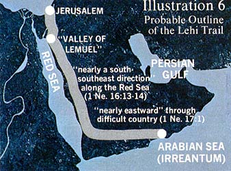
Illustration 6
Probable Outline of the Lehi Trail
Nephi’s care in specifying nearly south-southeast and then nearly east allows us to make a very likely speculation about the location of their destination, the land Bountiful.
As Nephi described that land, it must have contained water, fruit, large trees for a ship, grass, wild honeybees, flowers or blossoms, a mountain, a shoreline, a cliff overlooking the depths of the sea, and metal ore. Incredible as it seems, the south coast of the Arabian peninsula from Perim to Sur has only one place in its entire length of 1,400 miles that meets that description. It is a tiny sickle of land curved around a little bay, about 28 miles long and only 7 miles wide, backed by the Qara Mountains. For three months of the year, the monsoon clouds gather on the slopes fronting the sea and cover them with summer fog, mist, and rain. This place is Salalah, in the state of Dhofar, the Sultanate of Oman. The coast in both directions stretches away in unbroken barrenness. We repeat, this is the only place on the whole Arabian peninsula seashore which receives significant rainfall and where large trees grow—and it is known to have been this way for well over two thousand years.
Our enthusiasm mounted as we read descriptions of the place. British explorer Wilfred Thesiger, who had visited Salalah in 1948, said: “The jungle trees are wreathed with jasmine and giant convolvulus and roped together with lianas. Massive tamarinds grow in the valleys, and on the downs great fig-trees rise above the wind-rippled grass like oaks in an English park.” (Arabian Sands, Middlesex, England: Penguin Books Ltd., 1964, p. 47.)
We next discovered the reason for its ancient traffic: Salalah is the only place on earth where frankincense trees are indigenous. Seedlings have been transplanted to Yemen and Somaliland on the African coast; but at the time of Lehi, Salalah held a near monopoly. (Van Beek, pp. 36, 41.) Pliny, a Greek naturalist (A.D. 23–79), described the land of frankincense bounded by the sea and by high cliffs. He said that only 3,000 families were even allowed to see the trees; during pruning and harvest such supposedly polluting factors as women or dead bodies were strictly forbidden. (Pliny, Natural History, H. Rackham, tr., London, William Heinemann LTD, 1952, 4:39.) The Periplus, which recounts the voyage of a Greek merchant of the first century A.D., tells fantastic stories of poisonous serpents that guard the trees and must be pacified by the smoke of a cheaper incense called styrax. (The Periplus of the Erythraean Sea, pp. 131–32.)
To say we were excited in learning of these statements is putting it mildly. Was it possible that Salalah, the beginning point of the frankincense trails and the only place on the Arabian Sea where there was enough timber to build a boat, could be the land Bountiful? We pored over the maps and ancient histories, trying to piece together Lehi’s possible route between Aqaba and Salalah.
We discovered that the main frankincense trail turned eastward near the 19th parallel. But in order for Lehi’s group to continue eastward once they arrived at Najran where the trail turns south they had to journey on a less-traveled alternate route of the frankincense trail that skirts the southern edge of the great Empty Quarter desert. Probably they were following the directions given by the Liahona. Thus the group avoided passing through the great pagan nation of Saba to the south (Van Beek, p. 41) with its prosperous capital city (anciently called Marib) and the agriculturally productive valley of the Hadhramaut. Perhaps Lehi did not want to further tempt some of the wayward members of his colony by exposing them to the temptations of the flourishing’ civilization which existed there. After having been in small settlements for years, would some members of the party have refused to go onward had they visited the major center to the south? On the lesser-used eastward route, in one place the water holes are sixty-six miles apart. To us, this routing explains the terrible hardships Nephi mentions (1 Ne. 17:1) before they arrived at the tropical or semitropical paradise of Bountiful.
We next wondered about the time it took to make the journey. From Jerusalem to Salalah is 2,102 miles. (See Illustration 7.) How fast do camels move? Donkeys? Here we relied on the assistance of Salim Saad, an experienced camel rider and a former British Army officer. Stationed in the Wadi Araba, he became friends with many desert Bedouins. He explained that a loaded donkey caravan can travel twenty miles in six hours. Drawing on his astonishing library of Arab history, he showed us an example of a camel caravan consisting of thousands of camels that averaged twenty-four miles a day on the Haj (Islamic pilgrimage) from Cairo to Mecca. The famous archaeologist Nelson Glueck, a novice camel-rider, reported personally averaging thirteen miles a day on a camel ride from Jerusalem to Aqaba. Pliny tells us of a journey from Timna in Yemen to Gaza on the Mediterranean seacoast in Palestine that required “sixty-five stages,” which presumably meant sixty-five days on the road. (Van Beek, p. 41.) From Timna to Gaza is a distance of 1,534 miles, which would average out at twenty-four miles per day.
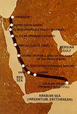
Illustration 7
Possible Route of Lehi’s Journey in the Wilderness
600–592 B.C.
Another measure is when the patriarch Jacob in the Bible fled with his sons and wives on camels with his cattle from Padanaram (Haran in Mesopotamia) to Mount Gilead, a distance of approximately 378 miles, in ten days (Gen. 31:18–23)—an average of thirty-eight miles per day. He was overtaken by his irate father-in-law Laban, who covered the same distance in seven days or fifty-four miles per day! If we consider all of these figures in computing an average, we can assume that Lehi could have traveled about twenty-four miles a day, regardless of the type of animal he used. In other words, they could have come from Jerusalem to Salalah in approximately ninety days. Yet Nephi reports that it took the party eight years to reach Bountiful. (See 1 Ne. 17:4.) Where did the eight years go?
Let’s start at the beginning. We can assume that the group didn’t dawdle getting out of Jerusalem and that they probably could have traveled at least as fast as Nelson Glueck or faster (thirteen miles a day). That means eight to twelve days between Jerusalem and Aqaba. From there, they journeyed “three days in the wilderness” and camped in the Valley of Lemuel. (1 Ne. 2:6.) Upon examining the maps and locale, we think that there is only one oasis that could qualify as this important campsite—Al Beda in the Wadi El Afal, Saudi Arabia. Here they may have stayed for as long as two or three very busy years, which would have included twice sending the sons back to Jerusalem on errands with a month’s traveling time each trip, plus the time needed to prepare for and recuperate from the journeys and the days spent haggling with Laban and collecting their gold and silver. There followed long days of studying and digesting the teachings of the brass plates. (How long would it take you to read thoroughly most of the Old Testament and to carefully think out its teachings—and then present them to your family?) And when Ishmael and his family joined them there would have been the preparation for the five weddings with the celebrations that followed.
It is also probable that Lehi would have used the time profitably by planting crops. This seems to be indicated by Nephi’s statement when the colony was about to leave the Valley of Lemuel: “We did gather together whatsoever things we should carry into the wilderness, and all the remainder of our provisions which the Lord had given unto us; and we did take seed of every kind.” (1 Ne. 16:11; italics added.) Yes, we think several years could easily have been consumed in these activities.
The Valley of Lemuel camp must have been a safe place for Lehi to rest. He had traveled three days beyond the shipyard town of Aqaba into the foreign nation of Midian and was, therefore, presumably beyond the reach of anyone at Jerusalem who still sought his life.
After the period at the first camp, the two families, now united by at least four marriages (Zoram was married to one of the daughters of Ishmael), packed up and moved south-southeast along the shore of the Red Sea to a place four days’ journey away that they called Shazer. We scrutinized the map, estimating that in four days they could have covered about 100 miles, which would have brought them to the oasis of Azlan in the Wadi Azlan. (See Illustration 7.) It represents the natural place for them to have stopped for a time.
We don’t know how long the family rested at Shazer, possibly long enough to plant a crop and wait for the harvest. But Nephi recounts that after a period they again moved, still heading south-southeast. (1 Ne. 16:14.) This time they seemed to have relied on hunting for their food. (1 Ne. 16:15.) Why? Had a crop failed? What kind of game did they find? In any case, they kept moving until “after … the space of many days” they pitched camp to rest and hunt food. Nephi does not mention a name for this campsite, but for them it was Camp Tribulation—Nephi’s steel bow broke and the family faced starvation since the others’ bows had “lost their springs.” (1 Ne. 16:21.) Possibly the family again tried to grow crops. We do know that Nephi, under instructions from the Lord, made a new wooden bow and went hunting again.
Possibly another harvest season elapsed before the families moved on in the same direction to Nahom, located at or near the nineteenth parallel. Here the stay may have been lengthy since the oldest member of the colony, Ishmael, died. (1 Ne. 16:34.) Surely, for his comfort, they would have tried not to travel; then there must have been a season of mourning before they pulled up stakes and moved on. Nephi specifically says in the case of the sojourn at Nahom that Lehi “tarried for the space of a time.” (1 Ne. 16:33.)
When the group left Nahom they turned “nearly eastward” and moved on until at last they arrived at Bountiful on the shores of Irreantum. (1 Ne. 17:1–5.) They had spent eight years in the wilderness (1 Ne. 17:4), and would spend an undisclosed period in Bountiful. We tried to estimate how long it would take to smelt ore, make tools, build a ship, and grow seeds for their voyage. Could it have been as much as two or three more years? Allowing for a four-year difference between established Bible chronology and Book of Mormon chronology, Jerusalem would have been destroyed while they were in Bountiful. Interestingly, by the time they arrived in America, Lehi had received a vision that confirmed the destruction of Jerusalem. (2 Ne. 1:4; see also 2 Kgs. 25:2.)
Thus our research ended. The route and the chronology as we pieced it together had Lehi joining one of the most heavily traveled routes of antiquity, the frankincense road originating in Salalah, Oman. For us, this explains the presence of named water sources, the direction the group traveled, and the people they undoubtedly met.
Now we were ready to test the hypothesis by driving over the ground, checking distances, seeing for ourselves the existence of the frankincense trail, and examining this centuries-old area which fit so well the description of Bountiful. We were ready for Arabia! (To be continued)
1. It is a “desert” from Judea to Petra (Strabo 16:4:21.)
2. Merchandise is conveyed overland from Leucê Comê to Petra. (16:4:24.)
3. Many people lived along the route. (16:4:21.)
4. Reports the caravan road from Petra to Leucê Comê could handle an “army.” (16:4:23.)
5. Arabia barren for want of water (16:3:1) and scorching heat. (16:3:3.)
6. Arabs keep camel herds. (16:3:1.)
7. “No trees” grow on Red Sea coast. (16:3:6.)
8. There is great wealth in southwest Arabia. (16:4:3.)
9. In Ma’rib, frankincense is bartered to merchants from Aqaba, who make the journey in seventy days. (16:4:4.)
1. Nabataeans control the road from Leucê Comê to Petra. (Periplus 19.)
2. Different tribes inhabit the length of Arabia from Leucê Comê to the Indian Ocean. (Periplus 19.)
3. By Muza are nomadic people who keep sheep and camels. (Periplus 20.)
4. Muza is crowded with Arab shipowners and seafaring men, and is busy with commerce. (Periplus 21.)
5. Ocelis is a market town and watering place. (Periplus 25.)
6. Camels carry frankincense in Arabia. (Periplus 27.)
7. At Moscha (probable “Bountiful” of Lehi Trail) frankincense “lies in heaps all over the country,” and it is exported from this locale. (Periplus 32.)
Route 1: Go east to Jericho across the Jordan River, then follow the King’s Highway from Ma’daba down to Aqaba. Route 2: Go east almost to Jericho, south along the west shore of the Dead Sea, then through the Wadi al ‘Araba to Aqaba. Route 3: Go south to Hebron, southwest to Beer-sheba, continue down Wadi al ‘Araba to Aqaba. A variation of route three leaves that route at Hebron and joins route two south of En-gedi.
(The first name at each location is the modern name, followed by the ancient name from the Book of Mormon, the Bible, or an ancient source.)
Photography by Gerald W. Silver
The King’s Highway runs south on the plateau above the east shore of the Dead Sea, then follows the Wadi al ‘Araba to the Gulf of Aqaba.
The city of Jerusalem, site of Lehi’s preaching. Solomon’s temple used to stand where the Moslem shrine Dome of the Rock now stands. Only the Wailing Wall remains of Herod’s reconstructed temple. Modern Jerusalem nearly surrounds the older city and its walls, built by crusaders in the Middle Ages.
Illustration 3. This stone relief from the palace of Sennacherib in ancient Nineveh illustrates the 701 B.C. (probable date) Assyrian capture of the city of Lachish in Judah. This detail shows the dress of a Jewish captive within a century of Lehi’s day and within twenty-five miles of Lehi’s city of Jerusalem. It also shows how seventh-century B.C. Jews loaded a camel. Lehi and his group, once they were on the desert, probably looked much like this. (Photo by Israel Museum at Jerusalem.)
Top: Beer-sheba, “the well of the oath,” was named by Abraham and Abimelech hundreds of years before Lehi left Jerusalem. (See Gen. 21:31.) But Lehi may have passed through this oasis village if he took the southern road out of Jerusalem. Bottom: If Lehi took the southern road out of Jerusalem, it would have taken him near the fertile valleys and wooded hills of Tarcomina, near Hebron.
Top Left: A modern highway follows the route of the ancient eastern road out of Jerusalem. If Lehi took the eastern route, which later divides into two routes, he would have used this road. Top Right: Jericho, one of the oldest cities in Palestine, has stood for millennia seven miles north of the point where the Jordan River flows into the Dead Sea. If Lehi took one of the eastern routes, this is where he would have chosen whether to go south along the west side of the Dead Sea or to cross the Jordan River to follow the King’s Highway. Lower Left: If Lehi took the King’s Highway southward, he would have traveled past Petra. The Suq, the narrow gateway to Petra, was carved through solid rock by an ancient river. Petra grew wealthy by taxing every caravan that passed by on the King’s Highway. Above: The country of Moab in early spring, as seen from the King’s Highway. Lehi may have traveled through here if he took the easternmost route out of Jerusalem. The limestone is so plentiful that even the homes are made from it.
Top: The oasis of En-gedi comes as a surprise on the desolate west shore of the Dead Sea. If Lehi went south by this route, he would have stopped for water at this or one of the other freshwater springs near the Dead Sea. Bottom: This modern highway along the west shore of the Dead Sea follows the ancient route Lehi would have traveled had he taken this route southward. We are looking south.
Above: At the head of the Wadi al ‘Araba. Here we can see where the routes out of Jerusalem merged together, coming from the north through the natural valley openings we see in the distance. This photograph is taken from the King’s Highway, which joins the other trails a few miles to the south. Right: The Gulf of Aqaba is the northeastern arm of the Red Sea. Lehi passed by or even stopped for a short time here as he traveled “by the borders near the shore of the Red Sea.” (1 Ne. 2:5.)
Top Right: Salalah, on the southern coast of Oman, is the area that the authors think is the land Bountiful of Lehi’s day. Bottom: Sycamore fig trees grow in Salalah, the only place on the southern Arabian coast where trees grow large enough to be used for lumber.
Far Left: In the winter, dry grass of the hills of Salalah is harvested. Top Center: The cliffs at Salalah, possibly the site where Nephi’s brothers thought to throw him into the depths of the sea. Bottom Center: The wall of the modern village of Salalah. Above: On the hills north of Salalah. Below: The slopes of the Qara Mountains at Salalah are an amazing change from the surrounding desert.
Top: The man who farms this Salalah alfalfa field told the authors he sometimes harvests as many as ten crops in a single year. Center: Corn, rice, cabbage, and many other vegetables and fruits grow in the well-watered portions of Salalah. Below: One of the streams at Salalah. Lehi might have camped near this stream if Salalah is indeed the land Bountiful. The authors’ guide carried a rifle as a precaution: rebels were still fighting in the Qara Mountains. Right: Sunset at the beach at Salalah. Fishing boats still sail from this bay, where Nephi may have built his ship.