“In Search of Lehi’s Trail, Part 2: The Journey,” Tambuli, Aug. 1977, 11
In Search of Lehi’s Trail, Part 2:
The Journey
After nearly four months of hurried preparations, we were ready to go to Arabia. Our friends in the Middle East were alerted. Our heads and briefcases were stuffed with information from ancient documents, modern explorers, and hints from the scriptures. Armed with a real sense of mission and the expectation of the thrill of adventure, we left Salt Lake City on January 15, 1976, to follow as much of our reconstruction of Lehi’s trail as possible. Jerry Silver, a superb photographer from Salt Lake City’s Deseret News, and our 25-year-old daughter Cynthia, of Washington, D.C., accompanied us.
The U.S. State Department counseled us to make the journey in reverse, beginning in Salalah, Oman, on the Arabian Sea, and ending in the city of Jerusalem. This procedure would minimize our entry difficulties—which nevertheless were going to be numerous—in the four countries through which we needed to pass. Uncertain military conditions made it impossible for us to visit two areas: a stretch in Saudi Arabia along the Red Sea where we think Lehi traveled between the valley of Lemuel and Shazer, and the desert stretch from Abha east to the Arabian Sea which we think was Lehi’s route to the land Bountiful. But we flew over parts of that section and otherwise felt satisfied that we had covered the route which we think could be most reasonably constructed as Lehi’s trail. Although we traveled the route in reverse, we shall present our findings in the order Lehi would have encountered them.
We are very much aware that our conclusions about Lehi’s life-style in the desert are accurate only to the extent that the Bedouin life-styles we observed still resemble those of their ancestors 2,600 years ago. What we saw was most helpful and illuminating, but it cannot be taken as proven fact without a great deal of supplementary research in archaeology, anthropology, and linguistics.
We only had five weeks to spend in the Middle East on the project—another reason (besides our comfort) why we chose air-conditioned automobiles over camels or donkeys for transportation. Paved highways now cover much of the route—locked onto the ancient frankincense trails by the powerful dictates of wells and topography.
After Lehi left Jerusalem, he could not have gone very far in a southerly or easterly direction before coming to the desert. As we looked at the contrasting terrain—steep, jagged, and rocky around Jerusalem, yet barren, sandy, and relatively smooth in the desert—we became convinced that Lehi must have acquired camels before he had gone too far into the desert and probably as soon as he approached it. No matter which route he might have used to leave Jerusalem, he would have run into camel markets where he could have traded his donkeys for camels. He may have even had money with him which he used—leaving his gold and silver behind does not mean that he departed penniless. Those camel markets are still there—large, dusty, and noisy with haggling buyers and sellers.
We knew from 15 prior trips to the Holy Land that there are only two ways Lehi could have left the city of Jerusalem. The eastern way divides into two of the three main routes from Jerusalem to Aqaba. (See illustration 5 and p. of the July IM). We explored all three routes. We did not follow the variant route, which is still only a footpath over the steep Salt Mountain. Sa’adi Fatafitah, our friend who accompanied us over much of the route, had himself made this crossing on foot and assured us that it was still passable, though difficult. After appraising all the routes, we found ourselves slightly favoring the central route that goes nearly to Jericho, and then turns south past bleak Qumran, west of the Dead Sea, although a good case can be presented for Lehi’s use of the King’s Highway. A person following the Qumran route east from Jerusalem gets out of town quickly. The logic of the downhill terrain helps explain why Christians at the time of Titus chose it as their escape route.
The west side of the Dead Sea, which at 1,290 feet below sea level is the lowest spot on the face of the earth, is not an inviting place. We saw utter desolation there. The mineral-saturated water lies stagnant in the long geologic fault, but we were astonished to find many freshwater springs along that west shore. There is also an excellent beach which was regularly used as a trail in ancient days, according to Salim Saad, who had spent most of his life in the area.
It seemed to us that Lehi could well have chosen the west shore of the Dead Sea over the east because there he would still be in his native country, Judah, rather than the “foreign” nations of Ammon, Moab, and Edom through which the King’s Highway passed. On the west shore he also would have avoided the Jewish population centers of Hebron and Beer-sheba, where he might be more easily recognized as one whose life had been threatened while living in Jerusalem.
Wadi al ‘Araba
We wondered why all roads lead to Aqaba. It was certainly easier for us to understand it once we entered the Wadi al ‘Araba, the geological extension of the low-lying valley in which are found the Sea of Galilee, the Jordan River, and the Dead Sea. It is part of the remarkable “rift valley” system, extending all the way from the Beka Valley in Lebanon to far below the Gulf of Aqaba on the Red Sea in the south.
The northern portion of the Wadi al ‘Araba drains north into the Dead Sea. The southern end of the wadi flows south into the Red Sea. As we looked at it, we saw a wide, dusty sand plain, hot in the summer and chilly in the winter. High mountains jut up on both sides, from 5–18 km away. Rainfall is slight, allowing the growth of only an occasional clump of grass or tamarisk tree. Other than the King’s Highway, this plain is the only way south from Jerusalem. It has been intermittently populated by nomadic Bedouins from early ages. We saw many Bedouin tents, and goats, sheep, and camels browsing in the wadi: irresistibly, images of the ancient past unrolled before our eyes.
The Greek historian Strabo, writing in the first century A.D., reports that “the camel-merchants travelled [through this area] only by night, looking to the stars for guidance, and, like the mariners, also carried water with them when they travelled.” (Strabo, p. 121.) Lehi may have done the same. With his whole family along and his animals laden with provisions, Lehi would have not been able to elude any pursuer if there were any; and desert-dwellers, expert trackers, could have been hired to track Lehi down had he tried to hide.
However, we learned from our friends of the unshakable rule of the Arabian peninsula that may have been put to good use by Lehi—that of asylum. Once a sheik agrees to accept a refugee, the tribe must protect him against any of his enemies. Of course, if the sheik refuses him, he may be killed on the spot. Lehi may have benefited from this ancient code as he traveled from one tribe’s jurisdiction to another.
Provisions
We know that Lehi took “provisions” on his journey (1 Ne. 2:4); and we tried to determine what they might be. We know that they included his tents, and probably such food as wheat, flour, barley, dried sour milk, olive or sesame oil, olives, dates, a few cooking utensils, bedding, and weapons such as bows, arrows, and knives.
We accepted the invitation of a young Bedouin boy. His family was moderately well-to-do by nomadic standards. As we approached the tent, we could see everything they owned. There was a donkey feeding in the dooryard, a horse and camel in the distance, sheep and a turkey walking underfoot. Entering the flap of the stiff, black tent we saw handwoven baskets hung on the center poles filled with cooking pots, some baskets half-filled with waterskins. There were rugs and pillows surrounding the fire pit, with saddles and bridles in the corner. We could see their entire wardrobe in an old cardboard box pushed into the other corner. There were no windows, the only light came in at the tent door and from the live coals in the fire. We saw no toys; The heavy, black, goathair tent, with some white sections made from sheep wool, was anchored by ropes and tent stakes. The only water was in the waterskins.
There was a women’s section of the tent and the women of our troop were invited to try on some of their clothes and jewelry. The women wear black dresses beautifully embroidered with multicolored flower and animal designs. Their heads are always covered with a shawl which varies in color according to tribal custom. Black veils cover their faces when they leave the security of the tent.
The men’s clothing was simple, a long white shirt and sash in warm weather. In winter, they add a dark-colored aba, or overcoat, made of coarse, handspun wool from sheep. It is very warm and sheds the dew and occasional rains. It also takes the place of a blanket.
All of the foregoing description is of interest because the living conditions of the Bedouin have changed little since 600 B.C. Thus the possessions of our Bedouin friends may be similar to what Lehi’s group took with them on their journey.
Another reason why Lehi, despite his wealth, would certainly have been a traveling light, would have been a protection against marauding desert tribes who would naturally investigate a small caravan displaying many goods.
Lehi probably carried his provisions in goatskin bags, which we found are still used all along the trail in the Arabian peninsula.
In a market at Aqaba, we found a waterbag of ancient appearance made from the skin of a mature, large-sized goat. The front legs had been sewn together with a rawhide thong to form a handle, while the dorsal opening was also stitched together with rawhide. With the back legs tied off it became watertight. The animal’s neck was the opening of the waterbag.
This waterskin certainly looked old and well used, but we were still surprised when the man from whom we bought it informed us that it was at least 10 generations old. Skeptical, we asked how a skin could be tanned so that it would be pliable and watertight for that long. The merchant replied that his people fill a new hide or bag with honey and camel milk and bury it for six months. When the skin is taken out of the soil at the end of this time, the hair drops away and the skin is thoroughly tanned. Our Arabian friends corroborated that this is indeed one of the known methods of tanning and that it was not impossible for a well-tanned bag to last a family for two or three hundred years or longer.
There is no way a traveler could go overland from Jerusalem to the east coast of the Red Sea without passing through Aqaba; there are certainly no modern roads that bypass it. Lehi may not have wanted his family to rest long in the city—and, in fact, they pushed on three days’ journey into the wilderness—but they would at least have replenished their water supply and maybe even stayed overnight. By this time, they would have been traveling for 10 days to two weeks and the oasis with its stately date palms and brightly flowering oleanders would have been a welcome sight for man and beast alike. We saw at least two dozen sweet water wells, some only seven feet deep.
Near Aqaba, the clean blue waters of the Red Sea shimmer in the bright desert sunshine. The underwater visibility is an astounding 45 km. There are huge mounds of varicolored corals that fringe that beach for many km. and the clear waters teem with thousands of beautifully colored tropical fish. This spot would be a delicious change for Lehi from his 10-day desert march from Jerusalem.
We knew from our research that an iron and steel manufacturing industry had been carried on here since at least the ninth century B.C., and so we were frustrated to find that King Solomon’s ancient smelters are in a war zone.
Nephi, during his shipbuilding days in Bountiful, mentions that he made a skin bellows to help smelt the ore.
We were, therefore, interested to discover skin bellows in an old market area in Salalah, which we think is the land Bountiful. The bellows were hanging, blackened and neglected, on the wall of a blacksmith’s shop. The blacksmith told us that they had been used by his father, his father’s father, and so on back 24 generations (an estimated 600 years). We had never seen a bellows like them before; they were not the pump type, like European bellows, but were more like an accordion. The neck of the tanned goatskin was tied around a wooden coupling tube that fit into an iron neck which would, naturally, have been placed under the fire. It reminded me of a clay pipe dated 1,000 B.C. that we had seen in the Israel Museum in Jerusalem, which had also been used to carry air from a bellows to the forge. The four legs of the skin of this bellows of Salalah had been folded back and tied off carefully. The entire back end was open, with the skin fastened to two parallel sticks so that it looked something like a woman’s purse that snaps shut at the top. The blacksmith showed us how to grasp these two sticks in one hand, holding them open while we pulled the skin up, drawing in air, then closing them as he pushed the bag down, forcing the air out the neck. We were impressed that it really worked well; and we mentally wondered how this bellows differed, if any, from Nephi’s.
Seeing how painfully and how carefully tools must be fashioned in the desert made us realize the heroic stature of Nephi in being able to find ore, smelt his own tools, and then construct his own ship.
Before our trip, we had read some interpretations that Lehi had traveled “three days in the wilderness” from Jerusalem. (1 Ne. 2:6.) However, verse five makes it fairly clear that they started counting the three days from the time the group arrived at the “borders near the shore of the Red Sea,” which must have been Aqaba. However, something puzzled us in the text: Nephi talks about coming down “by the borders near the shore of the Red Sea” and traveling “in the wilderness in the borders which are nearer the Red Sea.” (1 Ne. 2:5; italics added.) What distinction was he making? Once we arrived on the site, it became more clear what Nephi might have meant.
The coastal plain is squeezed into the area lying between the Red Sea and the mountains on the Arabian peninsula. Its greatest width is 77 km. in the area close to Jiddah. (See illustrations 7 and 9.) Called Tihama by the local residents, it is the ancient route of the frankincense trail and the most logical route for Lehi’s party as well. We determined about how far Lehi might be able to travel in three days and made a sweep about that distance south of Aqaba to see if we might identify possible locales for the valley of Lemuel and the river Laman. Naturally, we examined every wadi system, shore, and mountain very closely.
The geographically logical thing to do—indeed, the only thing to do—is to turn away from the Red Sea and go east up the hills through the mountain chain in wide, sweeping bends. Former storms have filled in all of the rough places with a sand and gravel “roadbed” for 40 km. to the top (elevation 3,135 feet). People without animals could have traveled through these mountains by inching up the steep and rocky hillsides or by edging exhaustingly up and down the jagged summits, but obviously the wadi is a convenient superhighway—as the heavily laden camels passing our car in majestic disdain testified.
At the summit (see illustration 9), the wadi branches. One branch leads out to the desert in an easterly direction. But another wadi slopes many kilometers downhill to the south in leisurely sweeping curves all the way to the seashore. This wadi, El Afal, runs parallel to the east shore of the Gulf of Aqaba, but the mountains in between hid it from our view. We drove down this wadi, which we think represents the borders near the Red Sea, finally stopping at its oasis, a village called Al Beda, Saudi Arabia.
Thus, we pieced these geographical clues together with the description that Nephi had given us. Of course, this reconstruction is tentative, one problem being that it doesn’t seem to follow Nephi’s sentence sequence, even though his meaning could fit what we discovered. The borders “nearer” the Red Sea could have been the 28 km. between Aqaba and al Humaydah, where the trail and the beach are practically the same thing. Then the borders “near” would have been their turning aside to continue east and south through the 83 km. in the Wadi Umm Jurfayn and Wadi El Afal to Al Beda. When Nephi later refers to “keeping in the borders near the Red Sea” (1 Ne. 16:14), he was probably designating the area about halfway down the seacoast near Jiddah when they were once again traveling on the coast itself. But to us, our discovery of what “near” and “nearer” meant suggested an equally exciting possibility: that Al Beda could have been Lehi’s camp in the valley of Lemuel. We had a couple of clues that supported this tentative conclusion. It seemed clear to us that the “borders near” the Red Sea was the higher wadi in which they spent the bulk of their time, and the borders “nearer” represented the close coastal plain stretching eastward to its first range of mountains. Suddenly, Nephi’s terms took on great meaning for us.
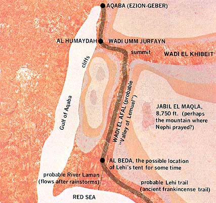
Illustration 9
Probable Location of Lehi’s Tent in the Valley of Lemuel (Also the route of an ancient frankincense trail)
|
Distance | |
|
Aqaba to Al Humaydah (traveling on the seashore) |
18 miles |
|
Al Humaydah to summit in Wadi Umm Jurfayn |
25 miles |
|
Summit to Al Beda in Wadi El Afal |
33 miles |
|
The “three days” journey (1 Ne. 2:6) could well be this total |
76 miles |
|
Al Beda (probable mouth of River Laman) to the Red Sea |
21 miles |
Father Lehi pitched his tent in a valley by a river of water that emptied into the Red Sea. (1 Ne. 2:8.) Nowadays, in all the Arabian peninsula there is not a single river of any significance which flows year round and reaches the sea. The annual rainfall in this area is between 1 and 2.4 cm. There is a little more in the mountains of Yemen on the southwest corner and in the Qara Mountains of Salalah, Dhofar, in Oman; but still they do not make running rivers. Hence, there are no real rivers that we can identify today with the river Laman. Nor do ancient records disclose one. Had there been one, people would have been living by it for generations. But this does not end the matter.
Old Testament Hebrew uses two words which in English are both translated as “river.” One word, nachalah, means “winter torrent” but is translated as “river” when it describes the Wadi al-‘Arish or the River Arnon. These rivers dry up in the summer. But thunderstorms characteristic of the winter season result in a true torrent. Our archaeologist guide and friend, Salim Saad, says that wadis run for two or three days after a rainstorm, and that in the Arabian peninsula the rainy season is almost completely limited to January and February. When the water rushes off the bare hills into the sloping, wide-bottomed wadis, “it comes with much force.”
The second Hebrew word, nahar, means a perennially “running stream.” The word is used in the Old Testament for the Euphrates River and the Nile, both of which are indeed ever-flowing. Thus, Hebrew takes account of variations in the meaning of “river”.
It is quite probable that after seeing a thunderstorm upon the watershed of Wadi El Afal, Lehi may have referred to a “winter torrent” or nachalah when he described the “river of water.” It is also possible that the spring at Al Beda formed a small stream that flowed south for 34 km. to empty into the Red Sea. What may have been a surplus of water at that time would now be absorbed by the more intensive cultivation in the oasis.
Of course, the Wadi El Afal and the Wadi Umm Jurfayn were not our private discoveries. They had formed a main part of the centuries-old frankincense road to Aqaba from the south along the Red Sea route; yet we saw few significant buildings or construction on the way. There were a few modern flood control dikes but not Bedouin tents in the main stream of these two wadis. At the extreme lower ends of most of the small laterals that funneled into the main wadi, however, we could see tents and flocks. There was plenty of camel fodder in the form of bunch grass and tamarisk trees in the bottom of these wadis, their leaves being peacefully munched by donkeys, camels, sheep, and goats.
We were driving on a new asphalt road that, as nearly as our guides could determine, followed the old caravan route. That would make sense since centuries of camels would gravitate to the easiest gradients and the camel drivers would adjust their wanderings to the shortest distance between two points. If our deductions were correct, we were actually passing over the route that Lehi had taken in Wadi El Afal. It was difficult for us to express our feelings. If Al Beda had indeed been the camp in the valley of Lemuel, then this was the base from which Lehi’s sons had twice returned to Jerusalem. This was the place where Lehi read and studied the brass plates and told his family their own genealogy. Here Lehi offered up several burnt offerings. Here he dreamed of the iron rod and the coming of the Messiah. Here Nephi had his own vision: of Christ’s mortal life and mission with his apostles, of the sailing of Christopher Columbus, of his own people among the great gentile nation in the promised land, and of the ultimate restoration of the Church. Here Nephi explained the allegory of the tame and wild olive trees. Here the seasonal business of planting and harvesting crops may have taken place, along with the great celebration of five desert weddings. It was also here that, to the colony’s great astonishment, the Liahona appeared outside Lehi’s tent to give counsel and lead them to their unknown destination.
Simply because a centuries-old frankincense trail existed even in Lehi’s time does not mean that Lehi knew how far he was to go on it, or where he might break from the more traveled part of the trail to pursue the lesser traveled portion. Thus, Lehi truly needed the Liahona. Of course, the Liahona was used and given to Lehi’s family as much for spiritual guidance as for directional guidance in their travels. The Liahona worked only when they were righteous. Refusal to repent caused them to lose their way both physically and spiritually. The analogy is instructive.
There are many magnificent mountains close about Al Beda into which Nephi could have been caught away for his comprehensive and detailed vision of the Savior’s mission and the major historical events till the end of time. (See 1 Ne. 11–14.) The highest neighboring mountain is 34 km. northeast of Al Beda; called Jobal Al Lawz, it reaches 8,514 feet above sea level.
Father Lehi named the river of water running in their sight after his eldest son, Laman. Nephi makes a point of recording that Lehi drew the moral of the river for his son when he “saw that the waters of the river emptied into the fountain of the Red Sea.” (1 Ne. 2:9.) Perhaps this implies that Lehi could not tell from his campsite that the waters emptied into the Red Sea. Al Beda is located 34 km. north from where the wadi empties into the Red Sea.
An examination of our maps and geography also suggested to us the meaning of the phrase “fountain of the Red Sea.” A fountain is the headwater, the spring, the source; and it is clear that the Gulf of Aqaba, serving as the northeast extension of the Red Sea, could be called the fountain of that larger body of water.
Father Lehi describes the valley of Lemuel as “firm and steadfast, and immovable.” (1 Ne. 2:10.) The modern appearance of Wadi El Afal is indeed that, its sandy bottom firmly delineated by solid mountains.
And so our hearts rejoiced. We had located a strong candidate for the site of the valley of Lemuel. We felt a special spirit in the Wadi El Afal near the oasis of Al Beda in Saudi Arabia.
Tents
Now we tried to visualize the details of that campsite, where, according to our estimations, Lehi could have stayed as long as three years. The most distinctive feature about the scene at Lehi’s camp that we constructed in our minds was the presence of tents. There may have been as many as nine after Ishmael’s family joined the group, one for each of the married families. If the tents we saw pitched throughout the Arabian peninsula were typical of those the inhabitants had used for centuries, we could get a pretty good idea of how Lehi’s tents looked. Actually, this is not an unfair assumption to make, for historians say that the tent, beit shaar (house of hair) has not substantially changed with the passing of time.
The Old Testament describes tents as “black” (Song 1:15), made of “goat’s hair” and containing partitions or “curtains” (Ex. 36:14), with a “hanging for the door of the tent” (Ex. 26:36).
The houses of hair we visited and studied were oblong and had a long pitched roof with drooping ends. The smallest tents had nine poles, the three tallest marching down the center with the three shorter running down each side. Guy ropes, also handwoven from goat hair, extended outward to stakes (also called nails anciently) driven in the ground. (See Judg. 4:21.) Each tent is divided laterally into two or more living sections by a curtain or curtains; at least one section for the men and one for women and children. (For a similar description, see Whiting, pp. 65–66.)
We have no way of knowing if Lehi’s tents reflected his economic status as a wealthy man or if he deliberately chose common black tents.
A camel gives about 10 pounds of hair a year; goats produce less. The hair is spun into strong threads by hand-held spindles. This thread makes a fabric as thick as carpet, very heavy and strong, but also very prickly and coarse.
The “house of hair” provides cooling shade in the hot summer, yet with the side panels tied down, it is warm in the winter. The tents are heavy, and even though they are mobile, it was obvious that Father Lehi would need pack animals to transport them. The average Bedouin tent is about 9 m. long and half as wide. (Whiting, p. 66.) A camel could carry one small tent; another animal would bear the tent poles, usually with one end dragging in the sand. The tents of sheiks (tribal chiefs), would correspond in size with their wealth, but they are built of the same material in the same way, in sections with lacings to fasten them together, each section designed as a load for a single animal.
Lehi must have stayed several seasons in some locations to make his journey in the wilderness last an entire eight years. It would seem that one of these extended camping places may have been the valley of Lemuel, where they may have planted crops. Lehi took “provisions” when he left Jerusalem, yet it is not likely that he took either a great amount or a wide variety. Nephi explains that after they had “dwelt in a tent” (1 Ne. 16:6) and had “tarried in the wilderness” in the valley of Lemuel (1 Ne. 8:2), they “gathered together all manner of seeds of every kind, both of grain of every kind, and also of the seeds of fruit of every kind” (1 Ne. 8:1; italics added.) Both wheat and barley were well known among Nephi’s descendants (Mosiah 9:9), and rye was known before Lehi’s day in Palestine (Isa. 28:15). Perhaps these are the “grain of every kind” that Nephi refers to. The book of Mormon talks of grapes, olives, and figs as fruits that its inhabitants knew. (1 Ne. 10:12, 3 Ne. 14:16.) Other fruits cultivated extensively in the Middle East in Lehi’s day, even though they are not mentioned in the Book of Mormon account, are dates, coconuts, and pomegranates.
It would seem very likely that Lehi’s colony either grew or purchased as many of these plants as possible while they lived in the valley of Lemuel. Since they came from an agricultural area and since there was a “river of water” (which, even if intermittent, could irrigate some crops) available at the campsite, they very likely cultivated their own crops and probably enjoyed a relatively varied diet during this period.
Weddings
In addition to these daily chores, we know of five joyful celebrations that took place in this valley—five marriages. No event in Semitic life is more celebrated by a family or more anticipated by a daughter than her marriage. It is the one day in her life when her importance is greater than that of the men. In the desert, preparations for these marriages are very elaborate, since not only the trousseau but a tent for the newlyweds must be made. Traditional customs demanded that the entire neighborhood population must be invited to the festivities. Not to invite everyone would not have made a culturally acceptable marriage.
Lehi’s four sons and Zoram, the former bondsman of Laban, were all to be married. Fortunately, there were exactly the right number of daughters in Ishmael’s family. For Ishmael to have had five daughters old enough to be married is most unusual; many girls are betrothed while they are only children and are married at age 13. It is even more unusual that one of those daughters, the oldest one, would have been willing to marry a former bondsman, Zoram.
It was customary in ancient Israel for the father or kinsmen of a young man to choose his wife and arrange for the marriage. No doubt Lehi, acting on behalf of his four sons, negotiated with Ishmael, even though the “negotiations” may have been mere formalities based on prior arrangements. Zoram, without family, was probably included in the negotiations as a son by virtue of Nephi’s promise that he should “have place with us.” (1 Ne. 4:34.)
If Israelite customs were followed, the negotiations produced five betrothals. Usually a betrothal began when the groom paid the dowry to the bride’s father as a compensation for the loss of his daughter, and ended with the wedding, a period which seldom covered more than a year’s duration. During the betrothal period, the couple referred to each other as “husband” and “wife” and it was understood that betrothal included a covenant of faithfulness.
Marriage in the Old Testament times required no government or religious sanction; it was a family affair consisting of a public covenant of falthfulness and acknowledgment of the marriage by the good wishes of family and friends. A fairly standard part of the wedding was a feast that sometimes lasted a week, enlivened with processions, music, and dancing. Considering the possibility that all five weddings were performed simultaneously, the celebration must have been lavish, perhaps including the local nomads as well in the festivities.
Moving Southward
After Lehi had accomplished all that was necessary at camp Lemuel, he found a brass ball of “curious workmanship” at his tent door. It contained two spindles that pointed the way they should go into the wilderness. (See 1 Ne. 16:10.) The Liahona has been called a “compass” at least five different places in the Book of Mormon (Alma 37:38, 43, 44; 2 Ne. 5:12; 1 Ne. 18:12), but it only worked according to the attention and the faith they gave it (1 Ne. 16:28), not according to the magnetic lines of the earth. One of the points, from time to time, also had writing upon it. (See, e.g., 1 Ne. 16:26–27, 29.)
While we were looking intently at our maps in Salt Lake City, we had wondered why the Lord gave Lehi the Liahona at that point, when all they had to do was travel down the well-marked frankincense trail. Looking at the scriptures and the landscape together gave us some ideas:
1. For the Liahona to point “the way whither we should go into the wilderness” (1 Ne. 16:10) was an indication to Lehi’s party that they should keep going south-southeast rather than crossing the sea at that point or going east into the mountains. This direction coincided with the relatively safe frankincense trail.
2. However, the “trail” was as wide as the coastal plain—up to 77 km at its widest point. Caravans seeking camel fodder would, of course, use its entire width. A little farther down the coast, after Shazer, Nephi specifies that the Liahona directed them “in the most fertile parts of the wilderness” (1 Ne. 16:14), possibly to patches of rain-fed grass as well as the more copious or less used waterholes.
3. The Liahona was the vital instrument when Nephi, with his newly fashioned wooden bow, asked where he should go to obtain food. The ball sent him “forth up into the top of the mountain” where, in fact, he did find game. (1 Ne. 16:30–31.)
4. Nephi does not mention the Liahona’s directions when they continued their trek, but surely it was the reason they traveled “nearly the same course as in the beginning.” (1 Ne. 16:33.)
5. Farther south and east, they had to make a decision of which route to take when the frankincense trail branches, one fork going south toward busy cities and the other fork going east on a more difficult route. Again, it was probably the Liahona that indicated that they should travel “eastward.”
Following the first directions given by the Liahona, Lehi gave instructions to break camp in the valley Lemuel. The group crossed the river Laman and then went in “nearly a south-southeast direction” for “the space of four days” to a place they named Shazer. (1 Ne. 16:13.) We calculated that this leg of their journey took them downstream to the shores of the Red Sea, where they continued down the Tihama. If we accept the 115 km from Aqaba to Al Beda as the three-day journey into the wilderness (38 km. per day), then a four-day journey would cover about 154 km. This would bring the colony approximately to Wadi Al Azlan, long an important and large oasis on the Red Sea coastal plain, which may have been the locale of Shazer. The area is now a stretch of sterile sand with gently rising mountains in the east and the brilliant blue of the Red Sea on the west. This route, of course, is the ancient coastal frankincense trail and thus would have presented no problems for city-bred travelers to follow.
Along this stretch of the coastal plain, there is no opportunity for a caravan to go inland, since the chain of wells lies down the Red Sea coast. Along the entire coast, we saw water wells that had been laboriously dug by hand and walled with stones. In terms of the accessibility of the water, desert tradition regards water as the gift of God to man, not something to be possessed and hoarded, but something to enjoy, rejoice in, and share freely with guests. Water is life in the desert; Lehi could not have traveled far without water for his family and animals to drink.
If we are correct in assuming that the growing seasons of those eight years were spent in raising crops, he must also have had to obtain access to irrigation water. We saw many ancient wells, springs, and cisterns on the route, flanked by modern drilled wells.
Sometimes, we saw continuously flowing springs with the stream carefully trenched to best distribute the precious water. But never once did we see a freshwater source without people and animals in the vicinity.
Large-scale maps of the route that Lehi may have followed, drawn by the Saudi Arabian Ministry of Natural Resources, show 118 old-type springs or wells over the entire distance. These maps distinguish between “dug” wells that date back, in some cases, for thousands of years and the “drilled” wells that have been brought into production within the past few decades. If we assume that the water available now from the old dug wells along the route is much the same as it was in Lehi’s time, we discover that the average distance between each of these water sources is 29 km., the longest waterless stretch being 106 km. The map shows us two sections from Aqaba to Salalah where water is so scarce that travel would be difficult. The first is the journey from Jiddah, in Saudi Arabia, to Al Qun-fudhah,which may have been Lehi’s camp Nahom, where Ishmael died. Here water was spaced out an average of 38 km. apart. The second sandy stretch appears on the eastward leg of the journey, running from Najran (near Nahom) in Saudi Arabia to Salalah in Oman, where water was found every 42 km. on the average. Interestingly enough, these two segments of the trip seem to have caused Lehi’s party the most suffering, according to Nephi’s account. (1 Ne. 16:20, 1 Ne. 17:1.)
The Broken Bow
The Book of Mormon tells us that Nephi and his brothers killed wild animals with bows, arrows, slings, and stones. (1 Ne. 16:23.) A local guide told us that he shot gazelles by the hundreds when he was a young man, just because he was “trigger happy.” He reported that in the hills are wild asses, gazelles, oryx, ibex, reem, pigeons, grouse, partridge, wild cows, hares, and such domesticated animals as goats, horses, donkeys, camels, and dogs. Usually the dogs are swift greyhounds, trained to catch hare. Called salukis, these dogs are popular among the nomads and almost every family has one. There are many other animals that Lehi’s party probably would not have considered eating but which formed part of the local fauna: wolves, jackals, owls, and snakes. Locusts, permissible under Jewish dietary customs (Lev. 11:21–22), are also found in the area. Bedouins consider them a delicacy and dry them and store them to eat year round; even the dogs enjoy them. The “locust season,” which comes only once in several years, is a kind of minor thanksgiving time for the desert dwellers. (William Tracy, “A Talk with Violet Dickson,” Aramco World Magazine, Nov.–Dec. 1972, 23:17.)
It was while we were traveling along the coast of the Red Sea in the vicinity of modern Jiddah that we realized how Nephi’s steel bow might have broken and how the wooden bows of his brothers might have lost their springs. (For biblical references to steel bows, see 2 Sam. 22:35, Ps. 18:34, Job 20:24.) The bow-breaking incident occurred after they had traveled “for the space of many days” (Nephi repeats that twice, both in 1 Ne. 16:15 and 1 Ne. 16:17) and had pitched camp to rest for a season. This would have been natural for a party traveling at a speed dictated by the presence of women and children. Since Nephi says that they again traveled “for the space of many days” (1 Ne. 16:33) to reach Nahom after leaving this camp of the broken bow, it may have been located half-way between Shazer and Nahom. This would locate the incident roughly in the vicinity of Jiddah, Saudi Arabia, where the weather is a merciless combination of heat, humidity, sand, and salt—a force strong enough to destroy steel! We were stunned to see holes that had rusted through car fenders in a few months’ time. Between March and November, the heat is pitiless. Even in late January, the temperature hovers around 29°C. Humidity averages about 60 percent year round, and in the moister part of a 15-year cycle, the humidity rises to a year-long average of 92 percent. Unpainted metal simply cannot survive such conditions. We saw little metal used in either local building or the shipyards.
Could this have also happened to Nephi’s bow? Weakened by rust, it could have snapped in his hands when he drew it to its limits. The climate would also explain why his brothers’ bows lost their springs at or around the same time. If they were wooden bows, they would have remained tensile and strong in the dry area around Jerusalem; but several years in the humid climate along the Red Sea’s coastal plain would inevitably have caused them to absorb moisture until they became as easy to bend as saplings. In fact, acquaintances of ours often reported similar experiences with some of their wood possessions.
This, then, was the problem facing Nephi, but he records that he found wood to build a new bow. (1 Ne. 16:23.) Our archaeologist friend Salim Saad enthusiastically pointed out that the pomegranate tree, which grows around Jiddah, would make a good bow. These trees grow throughout the Middle East, even in brackish water. Pomegranate is a relatively straight and close-grained fruitwood that is remarkably limber and tough.
In Lehi’s time, Jiddah would probably have been only a tiny village; today it is a great city of half a million people. As recently as 25 years ago, a letter was actually delivered in Jiddah addressed only “to the man with two trees.” Now, of course, there are many trees. At a shipyard at Jiddah, we saw men carving planks by hand, shaping the keel and bow with hand-operated drills, saws, adzes, and axes. We were successful in buying a hand-operated drill made of hardwood with a wrought-iron bit. It is rotated by a leather thong wrapped around it and attached to a bow. Although it looked primitive and awkward to our modern eyes, we saw it bore through hardwood planks three times each time.
In Yanbu, northward up the coast, we had been equally fascinated by the ancient-style saws used in another shipyard. The iron blade was stretched taut in a wooden frame, tightened by twisting a stick through a rope that connected the ends of the frame opposite from the blade. Again, despite its seeming primitiveness, it swished through thick planks with impressive ease.
We remembered Nephi’s explanation of his shipbuilding—that he “did not work the timbers after the manner which was learned by men.” (1 Ne. 18:2.) Apparently the shipyards on the coast had given him enough lessons that he knew, in following the Lord’s style of construction, that he was departing from “the manner of men.”
We marveled at the shipbuilders’ skill. When they shaped the ribs of their ship, they carefully chose a tree limb that bent naturally to the curve they wished and outlined the exact shape, chipping away with small hand-axes or adzes. They preserved the natural bends of the wood, using their feet and toes to hold the wood as they worked. As we gazed out at the Red Sea pondering, we wished that Nephi had included a few more details.
Food
Along the way, we accumulated more information about food. Desert-dwellers of antiquity apparently ate the same kind of food that modern Bedouins eat. In the Israel Museum, we saw evidence of produce that was grown locally back to at least 1,000 B.C., including barley, wheat, garlic bulbs, date seeds, lentils, olives, nuts, and acorns. Obviously, all of these things would have been common staples in the time of Lehi. They are the staples of life not only now, but were in ancient times as well Our Middle East historian friends consistently informed us that the major life-style of the desert has changed little over the centuries. All of the writers of antiquity who had first-hand experience with the Arabian peninsula describe a continuous succession of oases, villages, and drifting nomads all along the route Lehi would have taken.
While we were cataloging foodstuffs, we realized that we could not overlook the camel. To the desert-dweller, the camel is more than the “ship of the desert.” It represents a way of life, a special gift from God, an animal so important that over 700 Arabic names exist to describe the camel in its numerous varieties, breeds, conditions, and stages of growth. Camels have a life expectancy of 40 to 50 years, and female camels will lactate as long as four years after giving birth. Bedouins can and do live for months and even years at a time with nothing but the camel’s milk and dates as the staples of their diet. The milk of the camel is so precious a commodity that Bedouins allow the calf to suckle uninterruptedly for only about six weeks. Then they cover the mother’s udder with a leather bag and allow the calf to nurse only once or twice a day. The calf is soon weaned. (Thesiger, p. 231.)
Sheik Helwan Habtar of Abha, Saudi Arabia, explained that it takes about four camels to support one man on the desert; thus, if Lehi had tried to live exclusively from his camels’ products, he must have required a large herd to supply his group of at least 20 people. However, it is not likely that they followed this Bedouin practice completely, since they also hunted wild animals and probably cultivated crops at various stopping points.
Nephi’s mention of eating “raw meat” (1 Ne. 17:2) intrigued—and repelled—us, so we were surprised to find ourselves eating it in Cairo when our friend Angie Chukri served us this local delicacy. It was not dripping with blood as we had imagined it, but spicy with garlic and other flavorings. It had been allowed to dry in the sun until it was dark brown on the outside. But it was pinkish-red on the inside and soft to chew, not tough like jerky. Garlic was the dominant flavor, of course, but it left a sweet taste that changed our impression of the hardship of eating raw meat. Later, we saw raw meat for sale in Egyptian, Jordanian, and Saudi Arabian markets; it was formed in large loaves like bologna and spiced much like the pieces served us by Angie. Of special interest to us was the name the Arabs gave it—basterma, meaning “raw meat”—suggesting that Nephi’s terminology was not merely descriptive but the proper name. Was this process, or something similar, the method the Lord showed Nephi to make their food “sweet” so that they would not need a fire in the perilous passage overland from the Red Sea coast to Bountiful?
Nephi reports that the Lehi colony continued southward near the Red Sea, eventually pitching their tents in a “place which was called Nahom.” (1 Ne. 16:34.)When the colony moved again, “we did … take our journey in the wilderness … nearly eastward from that time forth.” (1 Ne. 17:1.) The frankincense trail turns east at the nineteenth parallel; it is there that Nahom may have been located.
The modern village that is located near the nineteenth parallel is A1 Qunfudhah in Saudi Arabia. We had special interest, of course, in observing their funeral practices and burial customs, for it was near here that Ishmael may have been buried.
If you turn east from this possible site of Nahom, the shore of the Red Sea ends in one high, rugged mountain range after another, jutting up from the sea to a height of about 3000 m. One of the ancient frankincense trails leaves the seacoast at approximately this same point and winds east through Wadi Ababish (see illustration 2), over the crest of the mountains to the village of Suda, joining the other trails at the caravan city of Abhal which is now a regional capital in Saudi Arabia perched 1800m. high.
The terrain also convinced us that Lehi might indeed have turned east near this point: the lack of other trails practically guaranteed it. The weathered carvings on the exposed rocks testified again that caravaneers for hundreds of years had passed this way.
At Abha, we met an extraordinary man at precisely the time we needed him. Helwan Habtar, a graduate of American schools with masters degrees in both political science and economics, took us to his home where he recited for us his family genealogy back 22 generations. Intrigued, three other men who had come by for the evening also recited their genealogies back as far as 13 generations. They were delighted that we would make tape recordings of them.
We were fortunate to be in Abha on a Tuesday, market day for so many hundreds of years that Mr. Habtar could not tell us when the custom began. There is a market area for honey, one for frankincense, others for myrrh, fruits, vegetables, cloth, clothing, donkeys, sheep, and camels.
Our attention centered first on those areas selling frankincense and myrrh. Frankincense comes in golden lumps about as big as the end of a finger while myrrh is reddish-brown and comes in rock-shaped chunks or as grated shavings. The frankincense was relatively inexpensive (a couple of dollars a pound), but myrrh is still costly because it is used for “medicinal purposes: every newborn baby is given a taste of myrrh in water to warn him of life’s bitterness; burning myrrh in a censer near a child’s sickbed is supposed to guarantee a quick recovery. A 45-year-old Arab in Jerusalem related how his mother had made him jump over a dish of burning myrrh when he was sick as a child. Now we understood one possible reason why the Wise Men brought myrrh to the baby Jesus: it was to help Mary keep him well.
(To be continued)
Photography by Gerald W. Silver
One of the many oases on the ancient frankincense trail along the west coast of Arabia. No traveler can survive long in this country without water; Lehi untdoubtedly stopped at many such oases during his journey.